Update: Sam & Dave’s “Excellent 2019 Vanderbilt Day”- #11 Bethpage #2
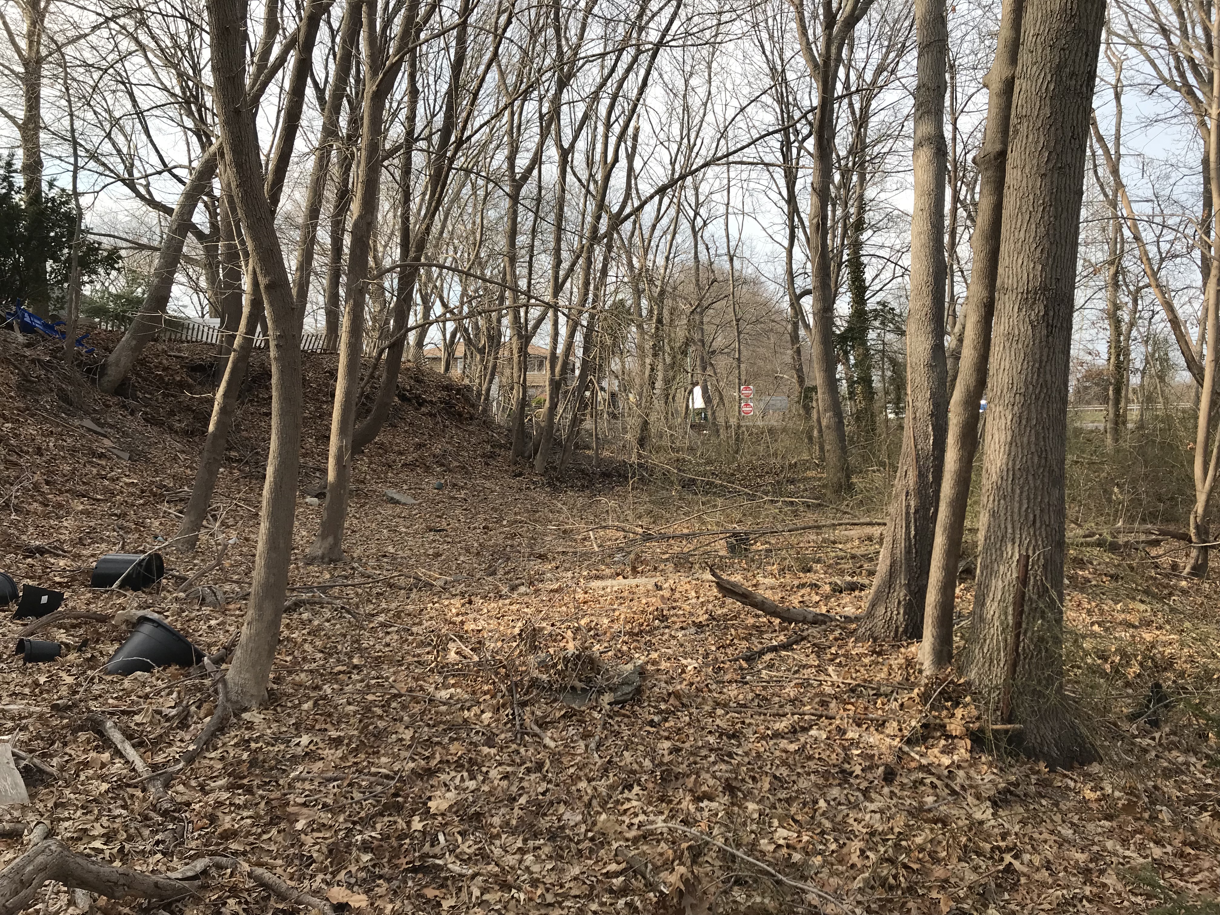
In the 11th post of the series, the father and son team of Sammy and Dave Russo explore the section of the Motor Parkway north of Deadman's Curve in Bethpage. Our favorite exploration team provide a video of road remnants that may be the Motor Parkway.
Enjoy,
Howard Kroplick
2019 Vanderbilt Day
March 30, 2019
Dave Russo :
So we did it yesterday. After a one year hiatus, Sam and I resumed our annual Vanderbilt Day tradition.
What better starting point than the Deepdale Mansion in Lake Success, William K. Vanderbilt, Jr.'s residence in the early 1900s. The home is still standing, just steps off of the Motor Parkway. I'm sure not by coincidence.
Moving west to east as always, we traveled 18 miles by bike from Lake Success to the Maxess Road Bridge in Melville We had a great time!
Dave Russo: Standing on former bridge abutment looking over Central Ave

Now here we go….I will go to the grave believing the LIMP did NOT in fact go east of 135 - there are just tons of remnants / fragments WEST of 135 and NONE on the east side. There is something wrong with the aerials for Wayne/Frank mapping purposes I believe in this location. There have been others who have chimed in over the years agreeing the LIMP was to the west. I wish someone would come forward with pics or proof of some sort but it's not just that people dug up the LIMP and threw the fragments to the west. The tree path is still able to be seen in some locations. The Caroline Street posts, well we'll get to that hold on….the LIPA lines that remain consistent throughout are to the west, there is just too much proof on foot for the west argument and NOTHING for the east.
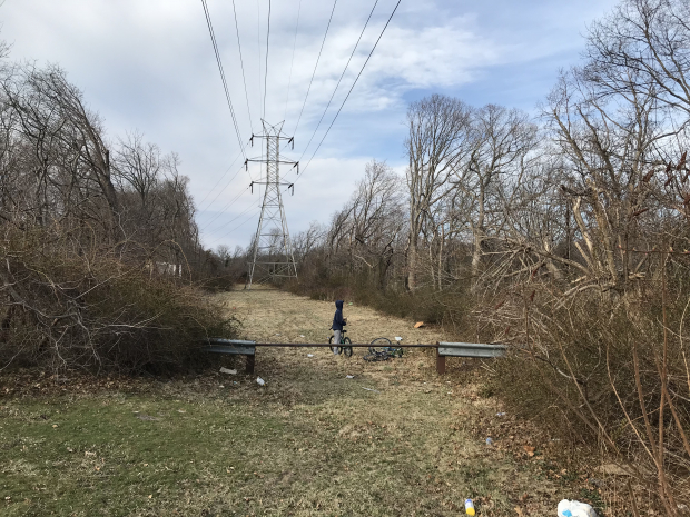
This pic is just east of Norcross Ave in Bethpage - and there are fragments throughout - I could send 20 pics showing fragments here
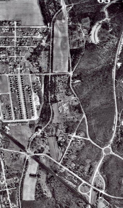
1950 Aerial of Bethpage

Piece after piece
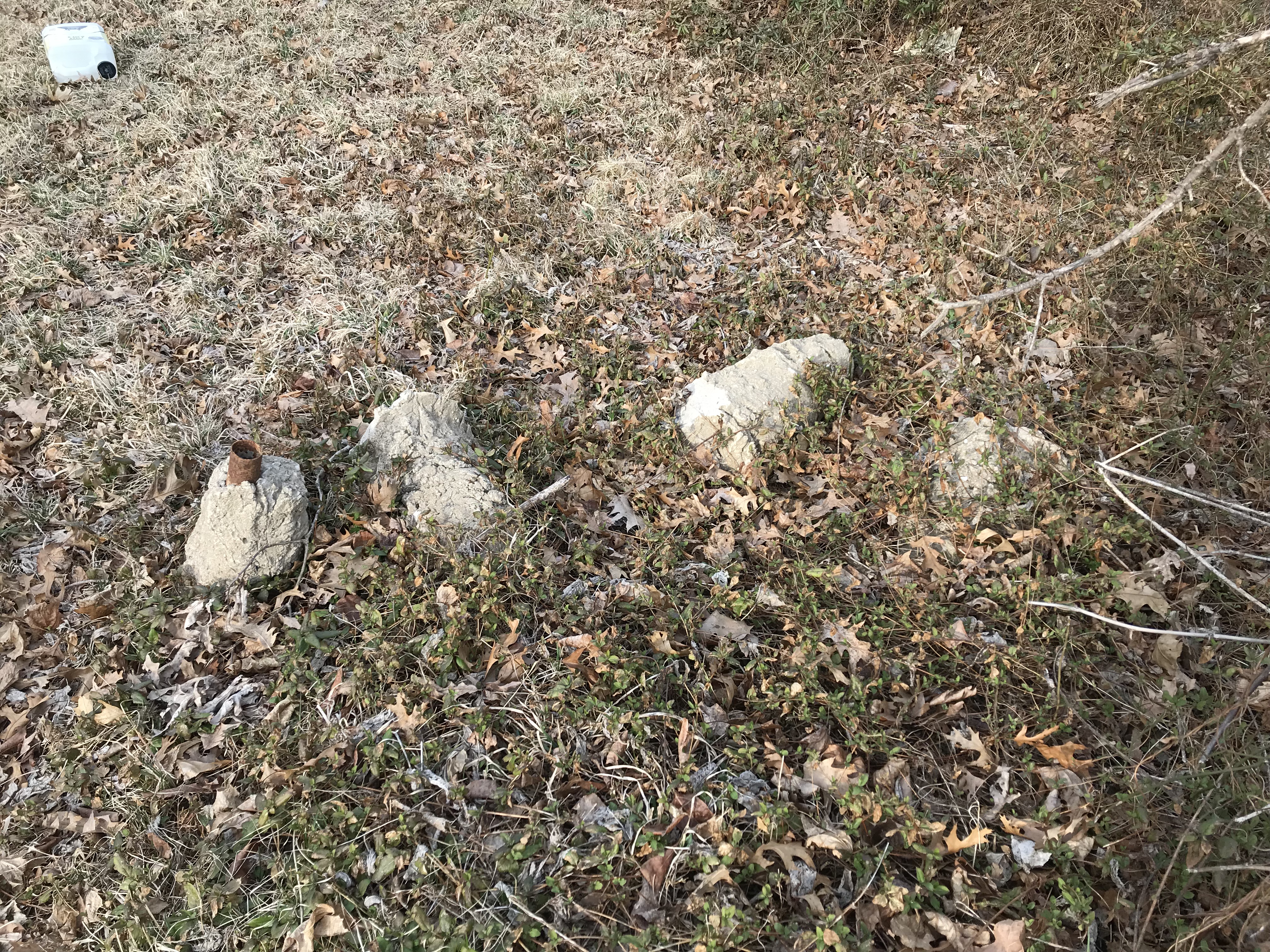
Sure looks like LIMP
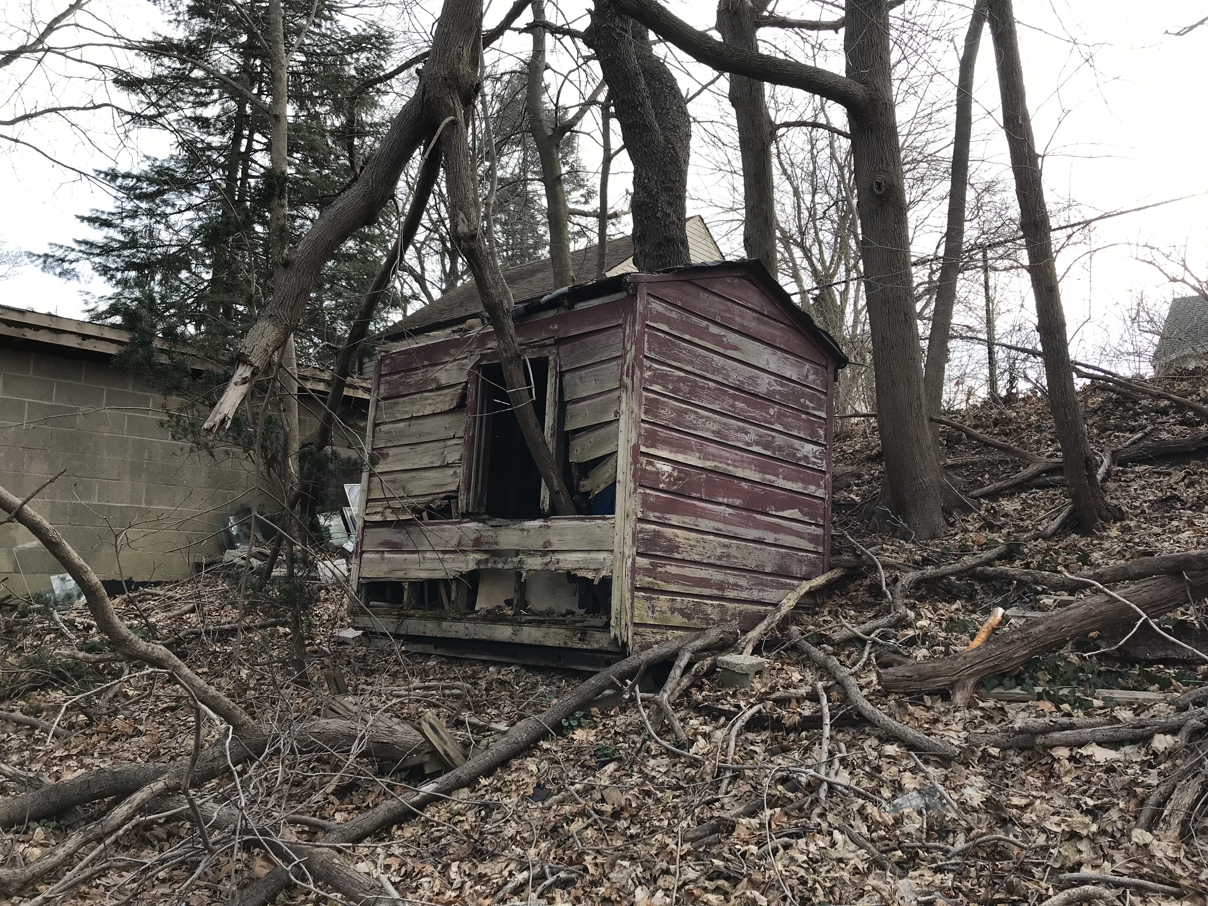
Thought this was cool - whoever played in this shed 50 years ago I'm sure knows the answer to this question! Come forward please!
More
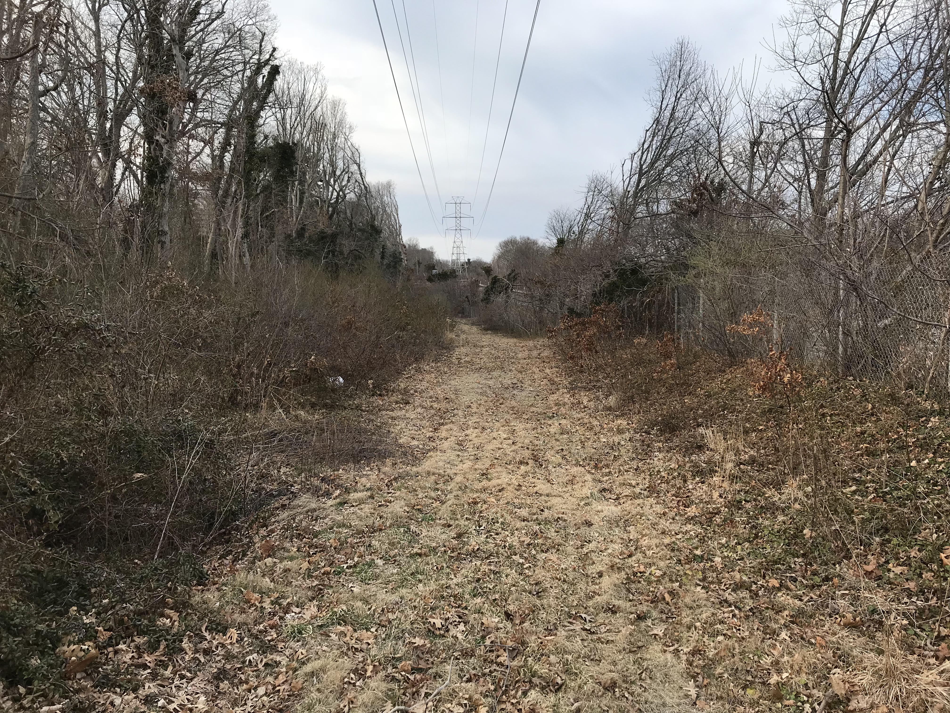
Leading up to Powell Ave, again it sure feels like LIMP where you are on there
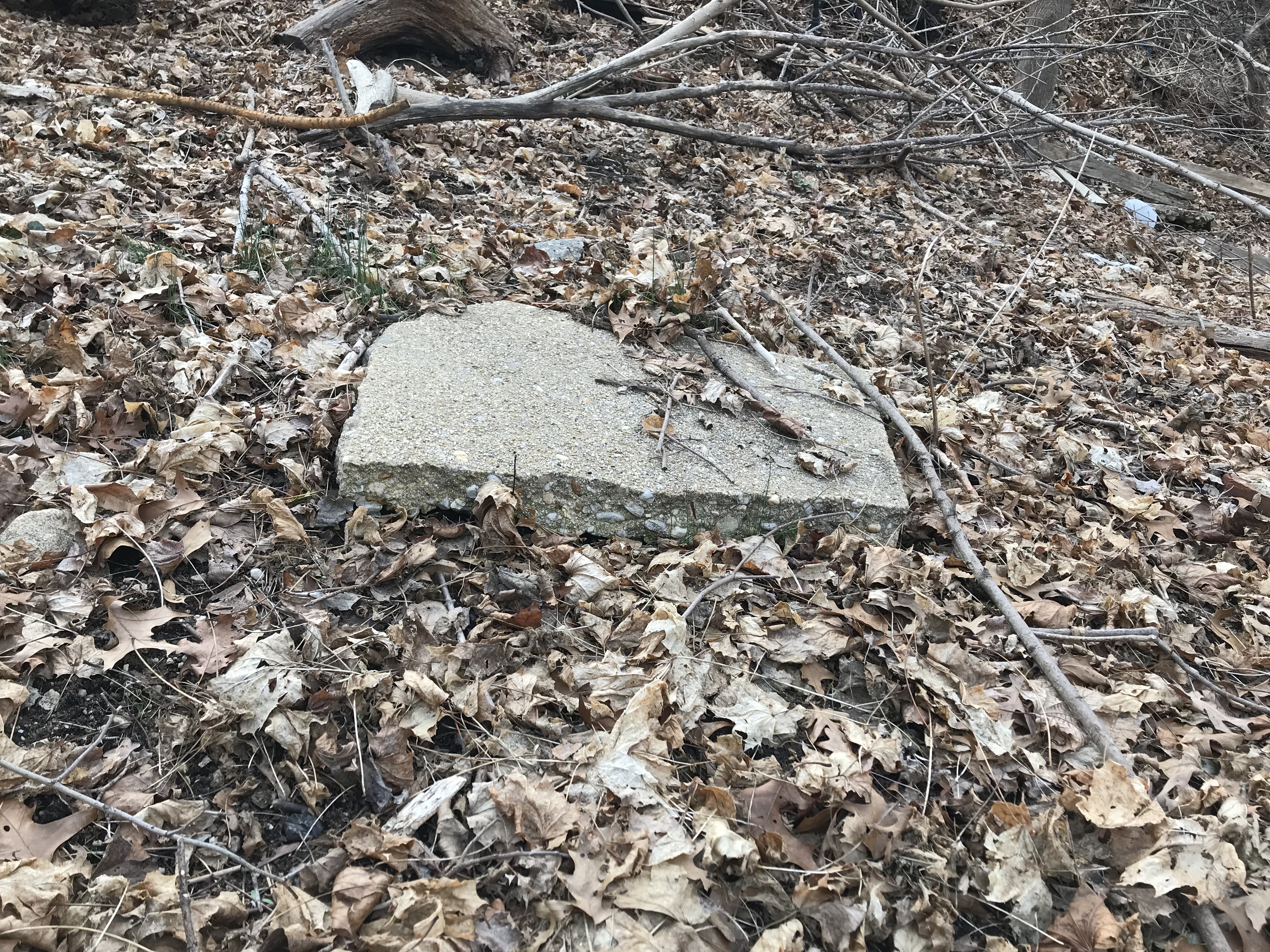
Perhaps proof?
Kleiner's Kolumn (Commentary by Art Kleiner)
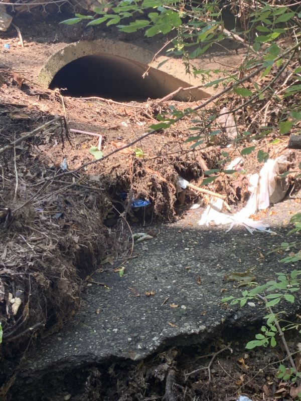
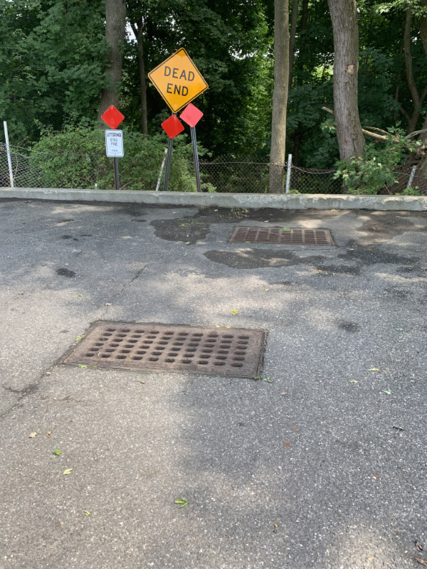
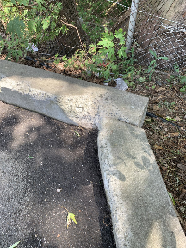
Took a ride yesterday to the area in question. Found a few new data points which I'll spell out here which may add to the discussion. At the end of Caroline Street and some streets to the north (i.e., Parkway Circle), there appears to be storm drains with access points leading into the area. The whole wooded area is listed in the Nassau County Tax Assessor files as a storm drainage area, which probably means there was construction at some point (possibly when the developer decided to change the names of the streets from numbered streets to names). The picture shown here shows on the top of the photo the end of Caroline with the drain going underneath leading to the asphalt. At the end of Parkway Circle there is actually an access point leading into the area with the same kind of concrete or cement down below.
End of Caroline Street
Storm drain access point at the end of Parkway Circle


Comments
I live on the west side of Norcross and was under the impression that the LIPA right of way where the pic is taken is slightly west of the actual parkway. I always thought the LIMP in that section is covered completely by the 135. Am I wrong?
The right of way is in the 1950 aerial right next to the parkway.
I went down that area some 2-3 years earlier, I had notice some of debris, seems more then than it shown now?, has more fencing now? appears to come from the back of the homes up on top, its possible those asphalt chunks came from the digging of the LIMP at 135 during construction? Also I had spotted a body of a blue 1957 Buick Roadmaster convertible minus the front end in that area. Dave, Sam, still there??
Guess I’ll chime in to Dave’s inquiry. Attached are a series of 6 aerials from historicaerials.com (overlaying 1953 and current) going from south to north beginning from where the LIMP crosses Central Ave. to where we can all agree it meanders east into Bethpage State Park. I’ve used arrows to point to the LIMP and have circled where the aerials show it crossing the future SOB (south of Revere Avenue), appearing to be on its east side for just a bit. After that point it appears to head back west slightly and actually shows up as being in the middle of the SOB south and north roadways (there is a median between the two at this point).
Just relaying what I’m seeing so others can make their own judgement. In any case, hope it helps the discussion.
And to add to the discussion, I’ve added 3 yellow question marks in the first picture where the LIMP crosses Central Avenue which appears to show a roadway leading into Thorne Avenue. If I didn’t know better, this looks like the LIMP but obviously can’t. Comments?
Three more in my series of aerials.
Note that there are 3 photos in each post. Hard to separate since there’s not a lot of space when they get posted. Perhaps a fix for this can be made.
Regarding the concrete monument markers that we all come across in connection with Parkway. Most, if not all of them are from when the Parkway turned just a 100 foot wide ROW over to Moses and the three county’s. It was at this time that the entire Parkway was resurveyed and the monuments placed. The rest of the property from which the ROW was carved out of was retained by the Parkway. Past real estate taxes were then paid off on these parcels and the properties were put up for sale. Over the years these concrete monuments have been removed, reused and replaced, so please, don’t read too much in where they are found today.. Regarding Art’s mention of Thorne Ave. That road was originally part of Central Ave. east of the Parkway ROW. When the SOB was being constructed Central Ave. was moved to the south of The railroad tracks.
Inside Old Bethpage Restoration Village along with many cement posts with the twisted ribbon wire.
Paul - when were your pics taken?
Not much question about overlapping I-135 now, eh? Just to make it crystal clear, I created a left-right comparison. Thanks, Dave and Art, et al. Sam, III
3 Yellow ??? Marks, Was the Old part of Central Ave. North,
Not the LIMP.
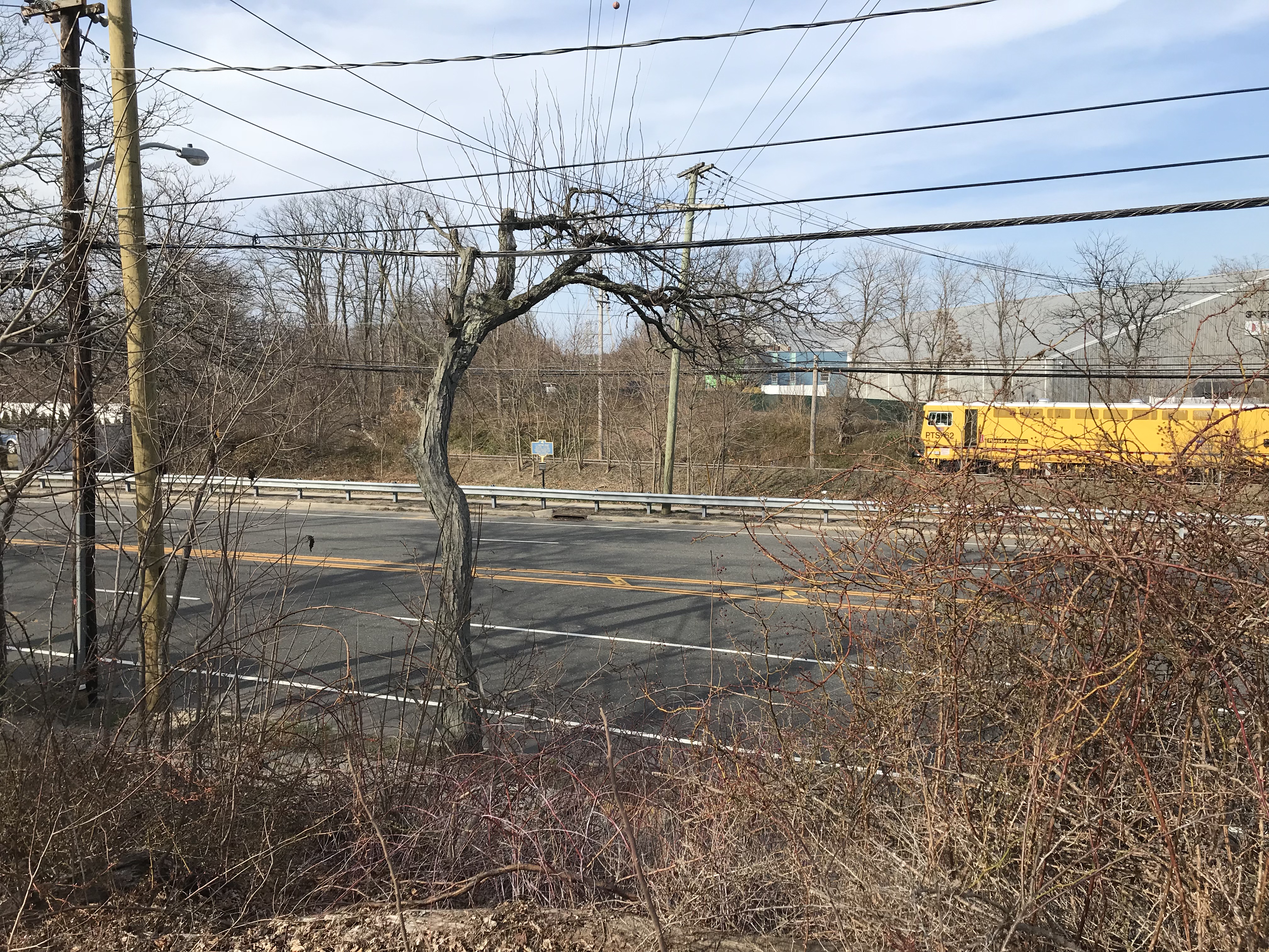
Mark—this is probably the car you’re talking about. I don’t know much about cars, but this pic was taken in 2017.
Aerials can be off. The angle from which they are taken in some areas often change. I don’t study this stuff but I recall when I took the pictures of the LIMP in Albertson just south of Sigsbee Ave - both LIMP maps are incorrect and about 30 feet off southward in this location.
Nobody is addressing the REAL point here…..I’ve been convinced for a while now that the ROW ran/runs WEST of 135. There have been those that have come forward with recollections of this being the case. The Caroline Street posts made no sense being where they are if you believe the LIMP was in fact on 135 at this point.
But my entire point is…..it was west of 135. And nobody has said anything about WHAT WE UNCOVERED! How can you dispute this? We dug this up! What else can it be??? It’s one thing to map things out from aerial footage, but what we dug up is in place to this day! And it’s right next to the Caroline Street posts. It makes total sense!
Last February
My final points -
1. I agree that the LIMP for the most part was west of the SOB but MAY also have been in places east.
2. Lots of construction/demolition occurs over 100+ years so I’m not always sure what I find is actually LIMP roadway or hasn’t been moved for demolition purposes. Educated guesses but I’ve been corrected a few times so maybe I’m a bit more hesitant these days.
For example by the Wheatley Hills golf course I would say have been moved so placement of objects are just one more piece of the puzzle.
I should have added that the well-worn path along the west side of the SOB, convincing though it be, and Howard, Al, and I went up and down there several times ‘way back, is NOT the LIMP. There might well be LIMP-like traces at the western end of the two bridges and just north of Central but NOT between Revere and Powell, except at the bridge site. Sam, III
Yes Dave, the photo of the Buick body shell in 2017 about the time I went down there, still there in recent visit?
Paul, Let me add some additional information that might explain the lack of road fragments on the east side of the SOB. On construction sites such as these where debris removal is necessary, the material being taken off the job site is usually first gathered up by heavy earth moving equipment and accumulated in large piles before being hauled away. My guess is the material to be removed was piled up west of today’s SOB. When the desired grade level has been reached, the area is then back dragged resulting in a debris free work zone Back dragging from east to west would account for the lack of any debris on the east side of the SOB. What remnants that have showed up from time to time I believe are from from the remains of one of these piles.
You can see with your own eyes destruction of LIMP RoW (in Bethpage State Park in 2006) at <http://sbiii.com/limpxpl2.html#bspatroc> and the debris pushed aside and piled up at <http://sbiii.com/limpxpl3.html#bspevdnc>. Ditto at the 1984 LIRR Main Line and Oyster Bay Branch bridge removals via Ron Ridolph’s pix at <http://sbiii.com/limpbrdg.html#rrbridgs>. Sam, III
Howard, That old Shed/Play House belongs to the Merin Family, they are my next Door Neighbors; I live on Norcross Ave in Bethpage and some of what Sam & Dave saw I have seen some of it many times in the past. That old Blue Car that sits just below my Garage & backyard and so does the Playhouse/ Shed I see that every day when I go out in my backyard. I remember several years ago mentioning to you that I saw what might be old Remnants of the Motor Parkway & sending you a few pictures I took 1 day while I was walking my Dog back behind my house on Norcross Ave where Sam & Dave walked but I never heard back from you about them other than you would check it out it when you got a chance, unfortunately what I sent by email was on my old computer which I do not have anymore (the hard drive went on it so every thing was lost from back then) Now I see that Sam & Dave have found more pieces & I am now even more curious about that Section of the Motor Parkway that you found down behind my house and block along the LPA/PSEG Right away near Route 135 which runs behind my house. I know mentioned that the Motor Parkway follows the LPA/PSEG Right away and that does run behind my Norcross Ave House in Bethpage.
The video does not show remnants / debris / pieces of roadway. There is plenty of that on the west side but that was not the point of the video.
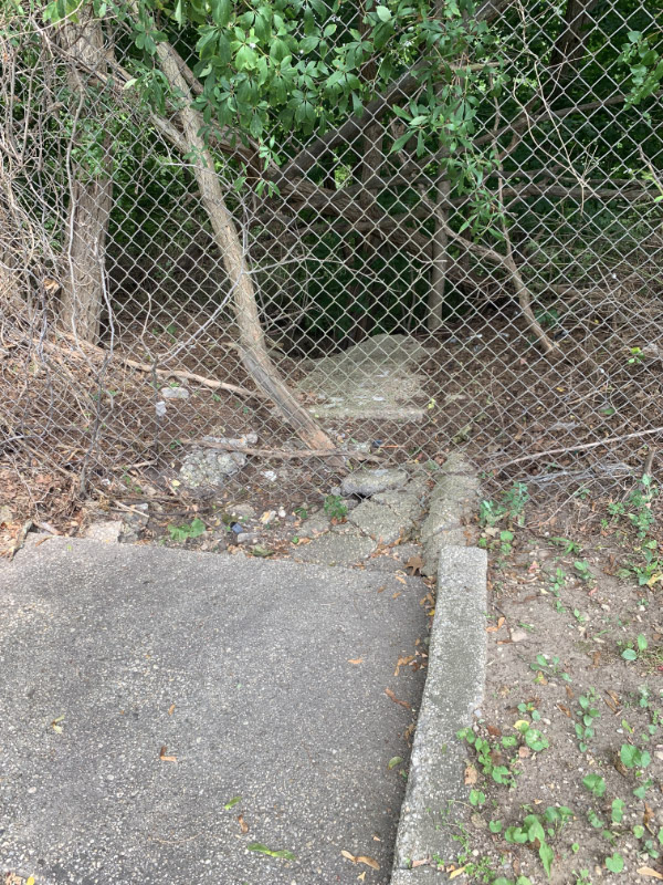
The video shows a section of IN TACT ROADWAY THAT WE DUG UP. Someone please explain to me——WHAT IS THIS if it’s not the LIMP??
The evidence is overwhelming! The only evidence for not believing this is aerials, which are not perfectly accurate at all. As I sited above: the Sigsbee Ave location in Albertson is 100% proven to be incorrect, by about 30 feet. Aerial angles can change and shift. You’ll be in the vicinity but not perfect! You just simply cannot argue with what you find on the ground still there and IN TACT! Someone please tell me what this is if it’s not LIMP.
Dave, please tell us EXACTLY where you dug. Ideally, locate it on an aerial or satellite view - or tie it in as closely as possible to a nearby cross-street and house number. If you have the ability, give us GPS coordinates. Then we can have a fighting chance to explain what you found. Sam, III
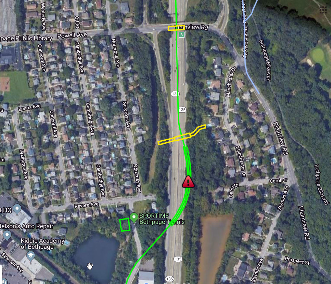
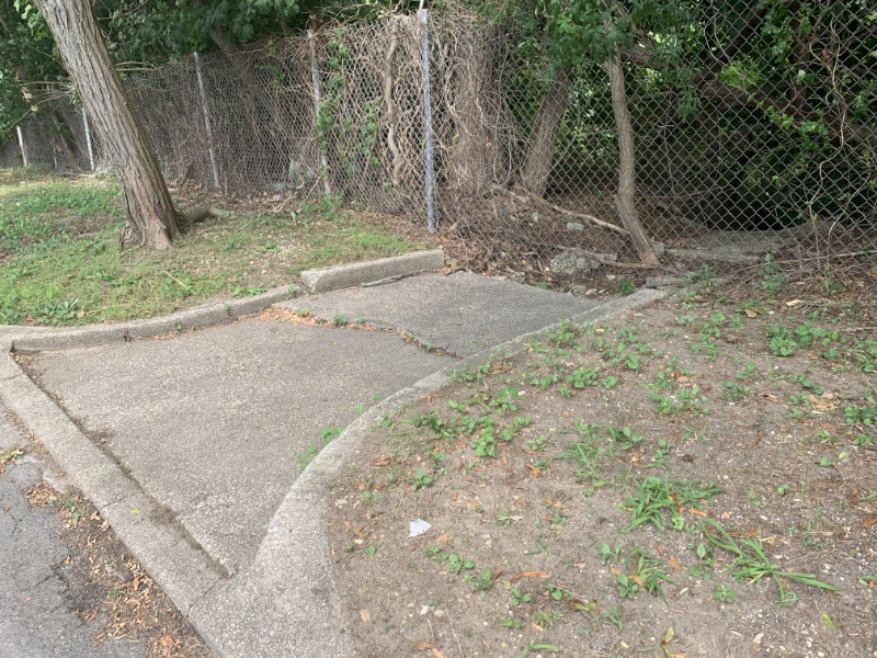
SBIII—- when you watch the video you get complete perspective of exactly where we are. We are just east of the end of Caroline Street. See the map. The mysterious “Caroline Street posts” are just north of us as you also see in the video. Their placement makes a lot more sense now! They are right alongside the LIMP, right where they should be!
This is an AH-HA moment - indisputable proof.
Here’s my 2007 website posting which gives a good idea of the location.
https://www.freewebs.com/limparkway/bethpagesob.htm
Adding to the discussion: the attached maps from 1939 and 1946 show Caroline Street as E. 4th Street and other named streets as number streets. My Hagstrom from early 1950s show the new names. And the 1946 map shows the area in question belonging to J. Botto.
Bingo, Dave; thanks. AH-HA, indeed! I couldn’t make out the Powell/Plainview off-ramp in the video but the spot seems to be where the green dot is on Frank’s map. That cluster of posts is NOT original; they were probably relocated there to block an informal access, much as those on the north side of East Williston Avenue across the south end of the RoW on the Wheatley Hills Golf Club were (what few are left standing). Sam, III
I’m still a bit confused. What you’re presuming to be the motor parkway is in the 1950 picture next to the actual parkway. Also, if the parkway goes where you claim it does, deadman’s curve #2 would not exist. I’m not sure what you dug up but i’m not sure how it could be LIMP remnants. Maybe discarded pieces of asphalt from 135 construction? Also, the house withe shed in the pictures above was built in 1929. Would a house have been built in such close proximity to the parkway?
Art - it almost looks like Caroline St has been extended a little bit further eastward since your early maps. Look at new maps, it seems like Caroline Street goes a bit further east now then it did. Maybe they added houses to the block since then?
SBIII—other then the E. Williston Ave (Wheatley golf course) location you speak of, no other posts have been picked up and placed in new spots like that. And somebody there probably did have historical perspective there as the LIMP went over the road pretty much at that location where they placed them.
The location of these posts do not block any access point. I’ve checked that a several times. See attached pic. You can see the backyard of the house is there. It is not the end of the street or any kind of path, they definitely do not block any sort of access of any kind. I brought Howard there one time to see exactly that! The posts are there. I really don’t think someone just picked them all up and planted them there for no reason. And couple that with the fact that we just dug up the IN TACT pavement perfectly in line with where the posts would then be…..how does that make sense????
John—-curve #2 was there, I just think the “starting point” of the curve was more westward, so when it came back it came back to this point. The aerials are off in this location.
A word of caution, here. Much as I appreciate the Hagstrom’s (and similar) images, and I use(d) my collection extensively, as you can see on my site, we can not (MUST not) use them for accurate locations; they are general representations, only. Sam, III
Art Kleiner - I’ve added additional commentary and photos to the blog post.
Congratulations with your position of Columnist for the website, Art. You lay all the facts out with no biased opinions.
A theory perhaps of The Caroline St Posts: 1926 map with the current street pattern, notice how they all dead end at the tree line. I pointed out the path that looks to be where the row of posts are. The parkway may have set these posts across the path seen to discourage the use of it since it leads to the roadway. Imagine planks or logs on one side and you have a barrier. Sure it didn’t totally stop usage of this path, but it was a quick/cheap fix. This path is still visible on the 1950 aerial above. I seen these posts up close & personal, too. These posts may have been set a 100 yrs ago.
I believe that Rte 135 was built over the LIMP ROW like Wayne & Frank’s maps show. And I totally agree with Al Velocci’s comment above explaining the road pieces/chunks that are found nearby. I can’t explain the flat exposed area of asphalt that Dave & Sam uncovered. Looks to be situated near the storm drain outlet pipe. Exposing more of it would be ideal, but attracting that kind of attention is unwise.
Dave - did the asphalt paving have a coarse concrete aggregate underlay, per the attached sample at Deadman’s Curve? LIMP paving was rolled aggregate with a concrete slurry poured into it and only got the asphalt later. If not, it is NOT original LIMP paving. All - I noticed that faint trace (highlit in red on the attached) on the long map above and see it is still there today, between the S/B and N/B lanes on I135/SOB; is that a police turnaround? It wasn’t there ‘way back. Whee; what a thread! Sam, III
Convincing evidence that continues to grow with excess debris on the west side, and have considered possibilities for their presence there. But I’m sorry I am unable to tie the debris to anything original LIMP. Other findings paint a different picture.
The Caroline St. posts today are located approx 250 feet from the center of 135 (the suspected location of the 22 foot LIMP). That makes it well outside the 100 ft ROW. Has anyone noticed there is only one post installed right side up at Caroline (the most left, south), with its convex head on top? All the others are installed upside down. This is not the work of Motor Pkwy Inc., it would’ve never passed. And how is it possible to have the roadway on such hilly terrain? The slope was always there. The tree line in the old aerials is the top of the hill/slope before the steep descent down, and where the streets terminate because of the slope.
The path under the wires on the west side again is definitely convincing, but LIPA also needs to keep their RoW clear so to move their equipment for servicing the wires.
Three small road fragments WERE found on the east side by Brian McCarthy and I a few years back. Photos of the remnants and their locations are below. They should still be there if anyone is interested. We inspected the entire area of the east curve (Deadman’s curve #2) with GPS, before losing the curve as it reentered into 135. This was all we found - 3 small pieces on the east and 2 larger pieces on the west, including a fully intact double-hole concrete post that was semi buried in the ground. We dug it out and stood it up against the fence behind the Sportime parking lot on Norcross (just SE of Nibbe’s cemetery). The post was very heavy and about 5ft in height. The location is on the pic below. We left those remnants there as well. Are these debris findings following a pattern - small or none on the east, and larger and more on the west? Regardless, my best guess was always - as some have mentioned here - the road construction debris was moved to the west, enabling some of the relocated materials to be reused/recycled as desired. I believe most or all of the debris found today was once used by LIMP, but their destruction/removal/relocation has nothing to do with their original location.
I agree with Al and Brian S that Thorne Dr was once old Central Av - which traveled under the long bridge and crossed the RR tracks.
Dave and all, those post are not from LIMP days, but from a later time, note the concrete is smooth not the rough appearance of original LIMP posts from weathering for over 100 years, and it has no holes for the wire cable fencing of them days. The large asphalt slab that you uncovered is just a large asphalt debris during the Rt.135 construction that was place there with soil covering it, they had the equipment to do it at the time.
Eagle-eyed Sam - Never noticed it before but Yes, definitely a police turnaround and complete, with “NO U-turn” signs posted in both directions.
Mark - Agreed! No holes because of upside down installation. Not the work of Motor Parkway Inc.. This multi-post phenomenon occurred sometime after. When? The world may never know…....
Found it! On my Nassau County Nomination Maps Continuation Page 1, <http://sbiii.com/limpmap1.html>, 8. Amityville Quad (1943) - Bethpage to Botto Farm gate/Bethpage State Park, is incontovertible proof (assuming one accepts the USGS Topo Maps) of the RoW in question (pertinent excerpt attached). I also found my Nassau County GIS Land Survey aerials from 1974 but that will take some work to present here - any interest? Sam, III
Ooh; look! On that 1943 Amityville Quad above, there’s the old pre-I135/SOB alignment of Central Ave.! Here’s a blow-up and a matching (sort of) current aerial with today’s Thorne Dr. Sam, III
Sam - Thanks, the 1943 USGS Topo still shows old Central Ave before the introduction of the 135 SOB. There is a dotted line veering northwest from the Powell Ave/LIMP jct that follows Dave’s theory. This is likely elevation change reference points (topography map) but It’s open for discussion. Anyone? This map should suffice but standby on those 1974 Land Survey aerials.
I stand firm on this map and other aerials already submitted but those findings are always open for discussion as well. Attached is a zoom of the suggested LIMP’s center line vs the shoulder solid line in the SOB southbound’s left lane. This is as close as I can get it.
Welcome Frank! I was waiting for your input! I thought you were going to shock us with some indisputable cartography!
CLOSING ARGUMENT:
*There are LIMP road fragments everywhere on the west side. Hundreds of pieces.
*When you walk this area west of 135, there are sections where you can see the tree-line of the former path. Why else would this be here?
*Posts are there - nobody has disputed in the past that these were LIMP posts. I realize they are different types of posts here but do you really think someone just randomly decided to find posts, install posts in this location so close to the LIMP with no other significance whatsoever, have them look exactly like LIMP posts but they aren’t? I’m not buying it. Not all LIMP posts have holes in them. There are several different types of posts.
*We dug up in tact road. This is not asphalt debris. This is in place road. What else could this be? The fact that water is funneled into this zone from Caroline Street means nothing. There are many locations on the LIMP that are now sumps, etc. It also seems possible that Caroline St could have been extended eastward to get closer to the LIMP then it was in earlier maps.
*Aerials have been proven to be off in the past. I don’t make a point to investigate each location but it was clearly brought to my attention in the Sigsbee Ave location in Mineola. I took a picture STANDING on the actual LIMP, and compared that with Frank/Wayne’s aerial maps, and it was off by 30-40 feet. This location is also an example of a huge slope on the side of the LIMP. See attached pic. Orange line is actual LIMP. Blue line is from aerial maps.
*People have come forward in past posts, people who lived through the construction of 135 and prior to 135 confirming the LIMP was on the west side. Nobody has come out in this post, but someone has to have a picture of LIMP prior to 135!
*Sam and I have explored the east side of 135 and found NOTHING. On the west side there are fragments everywhere. Were those building 135 instructed to bring all debris to the west side? Makes no sense.
I’m an “on the ground” guy. It’s amazing to have all the mapping information, aerials, etc. It is easier now to explore then it ever has been in history because of these advances, but sometimes ground exploration is necessary, and if there is a discrepancy of map vs ground, how can you argue with what you find in tact on site? I’m open to discussion if someone finds things on the ground to dispute our findings, but I’m not interested in computer aerials or maps from 80 years ago here, those can be off! Find an aerial of 135 under construction with the LIMP still in place! That would be wonderful. Someone has to have old pics! There has to be an older Bethpage resident that can answer this question with zero hesitation! The absolute proof exists somewhere but for now I have seen enough to believe the LIMP is on the west side of 135, but I will continue to make it my mission to prove to all one day! I thought perhaps this in place asphalt would do that for everyone, but you are a tough bunch!!!
We the jury find the evidence presented above to be convincing. We side with Sam and Dave until further evidence is presented! The LIMP was WEST of 135!
Frank, I don’t seem to have a good copy of the 1943 Amityville topo but here’s an excerpt of the 1947 version, basically identical, with ref. data, plus a blow-up of the exact area. The double-dashed line is marked “(ABANDONED)” and on the full map as “MOTOR PARKWAY (ABANDONED)”. No two ways about it, now; again assuming one believes in the USGS map or the military version from which it was taken. Sam, III
We’re out synch, here. Dave, you never answered my question about concrete underlaying your asphalt, without which it just isn’t LIMP paving. Similarly, your argument about those posts simply doesn’t hold water; no other LIMP posts are buried upside-down! There is third weird set of posts immediately south of the Clody bridge in Old Bethpage Village Restoration; see the 06 Jan 2006 picture <http://sbiii.com/limppix/obvr/pmmpob21.jpg> if you’re interested - it’s L - 21S on my main Exploration Page <http://sbiii.com/limpxplr.html#obvr12o5>. Yes, we’re a tough bunch - but only because you may well be beating a dead horse. Sorry. We all love you two, though; keep on trackin’! Sam, III
Dave - Congratulations, you win for typing the longest comment ever since this website launched. Most of us are “on the ground guys” too. We’re not just in our swivel chairs staring at the computer and disagreeing with everything you present. I’m no satellite expert either, but I have NO DOUBT that our mappers here would correct an imagery error if NECESSARY. Those old aerials you don’t care for are perfectly legit. We’re seeing what these airmen captured, I’d shake all their hands for what they did.
I’m ALWAYS on the lookout for images that may be unknown concerning the LIMP, and Howard will be the first one to know if I do. I don’t search for images to prove others right or wrong, I’m not a bully.I enjoy it, and look forward to sharing with others.
Dave - I’m not trying to shock anyone, and only trying to reveal the true history of the Motor Pkwy, as it lays in ruins in front of us to solve. FYI, my worst fear is to broadcast inaccurate data to infinite viewers online. This could be very damaging. I would not post anything unless there was credible evidence. I cannot connect the excessive debris findings in the west to anything original Motor Pkwy. Please submit further information here so we can all agree to your findings. I hope you prove me wrong. My only goal is to seek the truth of this 100 year old roadway.
Dave - that’s an excellent idea of obtaining photos of the SOB construction during the demolition phase. I’m hoping they exist and guessing they’re located deep within the Dept of Highways, Dept of Public Works, or a historic photo website/museum if any exists. I believe those photos if found, one won’t be comparing the old LIMP vs the new highway. I’ve seen these highway crews sweep the entire area clean first, then grade before applying any new concrete. The new RoW almost always takes a different shape and is larger than the previous one. The archived photos, if they exist, will be limited to comparing the LIMP’s former location against landmarks instead. But what a neat group of photos they’d be to add to the collection.
You guys are great. This site and everything related to LI History are great. I’m not “scolding” anyone. This is the type of thing you sit down for a few brews with and discuss and that is my vibe here. You guys are just all stubborn and wrong!! JOKING!!!
It will be my life mission to prove this. There has to be proof out there. It will be found one day.
Mayan ruins location is the other spot, I’m not at all convinced those were bridge side walls, I think there were just walls. Another day!!!
I am curious—- HOWARD??? You haven’t chimed in!!! What is your opinion???
Finally, what is the record for most comments on a post? This might be in the running!??
I have been looking for pre-WW2 pictures of Norcross Avenue/135 for a very long time and aside from the info available here, it has not been a successful endeavor. Since there seems to be some uncertainty when it comes to old maps and aerials, allow me to add to it. In both the 1950 aerial and the Amityville map, there appears to be a road continuing north into the park at the end of the Bethpage Parkway traffic circle that to the best of my knowledge, never existed. I know there were plans to maybe extend the Bethpage parkway at one time but I always thought there wasn’t anything completed. Anyone know the story behind this? I know it’s a bit off topic but I figure if anyone would know, it’d be you guys.
John, this should probably be on a separate post or private but here are the ‘47, ‘54, ‘69. and (20)16 topo maps of roughly the same area, but starting with a larger ‘47 to show the “MOTOR PARKWAY {ABANDONED}” callout. They show a steady degradation of the depiction of that mysterious northern extension of Bethpage SP from a full, paved, two-lane highway to zero. AHA! Wikipedia: “Moses proposed extending the Bethpage in both directions, south to Merrick Road via Massapequa State Park and north to Caumsett State Park, via an extended Bethpage and the new Caumsett State Parkway, respectively. Both proposals were not constructed; however, bike paths leading away from both directions of the parkway have been constructed or are under construction. Several scaled-back proposals to extend the Bethpage north have been proposed, including an extension to NY 25A in Cold Spring Harbor and another to NY 135 (the Seaford–Oyster Bay Expressway) in Bethpage.” Howzat for service, eh? At least this diatribe MENTIONS the LIMP! Sam, III
Ran over my allotted three attachments; here are the other two Amityville quad excerpts - ‘69 and (20)16. Sam, III
Art Kleiner:
I have a contact who used to work at the Nassau County Planning Commission and still has some contacts there and other related agencies. He’s asked around however things are a bit more formal these days. As such I’ll be submitting a Freedom of Information Law (FOIL) requests for whatever documents the NYDOT has pertaining to the building of the SOB and related areas of construction.
These are the records it pertains to:
“Record” means any information kept, held, filed, produced or reproduced by, with, or for this agency, in any physical form whatsoever including, but not limited to, reports, statements, examinations, memoranda, opinions, folders, files, books, manuals, pamphlets, forms, papers, designs, drawings, maps, photos, letters, microfilms, computer tapes or disks, rules, regulations or codes.
We can only hope some useful information will be uncovered.
Whoops! Completely forgot to mention that, many years back (ca. 2000?), an old-timer whose veracity I never had any reason to question, insisted that there were a set of closely-spaced LIMP posts in a W-to-E line in the brush immediately N of the BSP circle, i.e. - directly across the questioned RoW, perhaps as marked on attached aerial. A detailed search of that spot at that time never did turn up any such but I throw this in the pot just for the record, for whatever it’s worth. Sam, III
Thanks Sam! Those posts north of the circle are quite a distance from the LIMP (0.33 miles, ~1700 ft). I don’t disagree with your friend’s findings but could indeed also show how construction debris was distributed in the area, even to the east side. There were many posts uplifted here where some no doubt survived the onslaught. There’s one right now on the west side fully intact!
You are correct with proposed construction. Clearly remembering the old Hagstrom maps, dashed or dotted lines meant proposed roadways. That’s what appears here on the ‘47-54 maps as well.
Speaking of posts, I just remembered a stretch of LIMPISH concrete posts that are in the extreme r/o #600 Broadway - Bethpage Worship Center, near Cherry Ave. Know this is well outside the parkway row, but directly north. The posts are arranged along the north east side of this property. Just looked at this location on street view, able to zoom into the wooded area where I seen them. No doubt the posts were set with purpose. If I had a camera or iPhone in the early 1990’s, would’ve took a photo. Posts are likely still there.
Thanks Brian, another site to check out!
Here’s another document applicable for this thread. Nassau County Tax Map from 2003, showing the Motor Parkway roadway heading directly into the Seaford Oyster Bay Expressway below Revere Avenue. Also showing Thorne Avenue as Central Avenue as I believe Al V. had pointed out. May not be anything new but thought it interesting.
My FOIL request is still outstanding. Supposed to hear something within 20 business days from when it was acknowledged (Aug. 16th) so hopefully soon. But I’m not holding my breadth!
Nice find Art! Never thought about the tax maps. Leave no stone unturned. Excellent!
Revere and Lex? DING! That’s where the LI Aviation Country Club hangar roof is still extant (over Best Market HQ on Lot 594). This just gets better and better. Funny how that one chunk of RoW survived as a property. SO MUCH of the LIMP in this area! Sam, III