Mystery Friday Foto #1 Solved: A 1956 aerial over the Meadowbrook Parkway Extension

The Cradle of Aviation challenged you to identify another aerial.
Answers to the Mystery Foto questions:
Identify the following;
- Location and orientation of the photographer
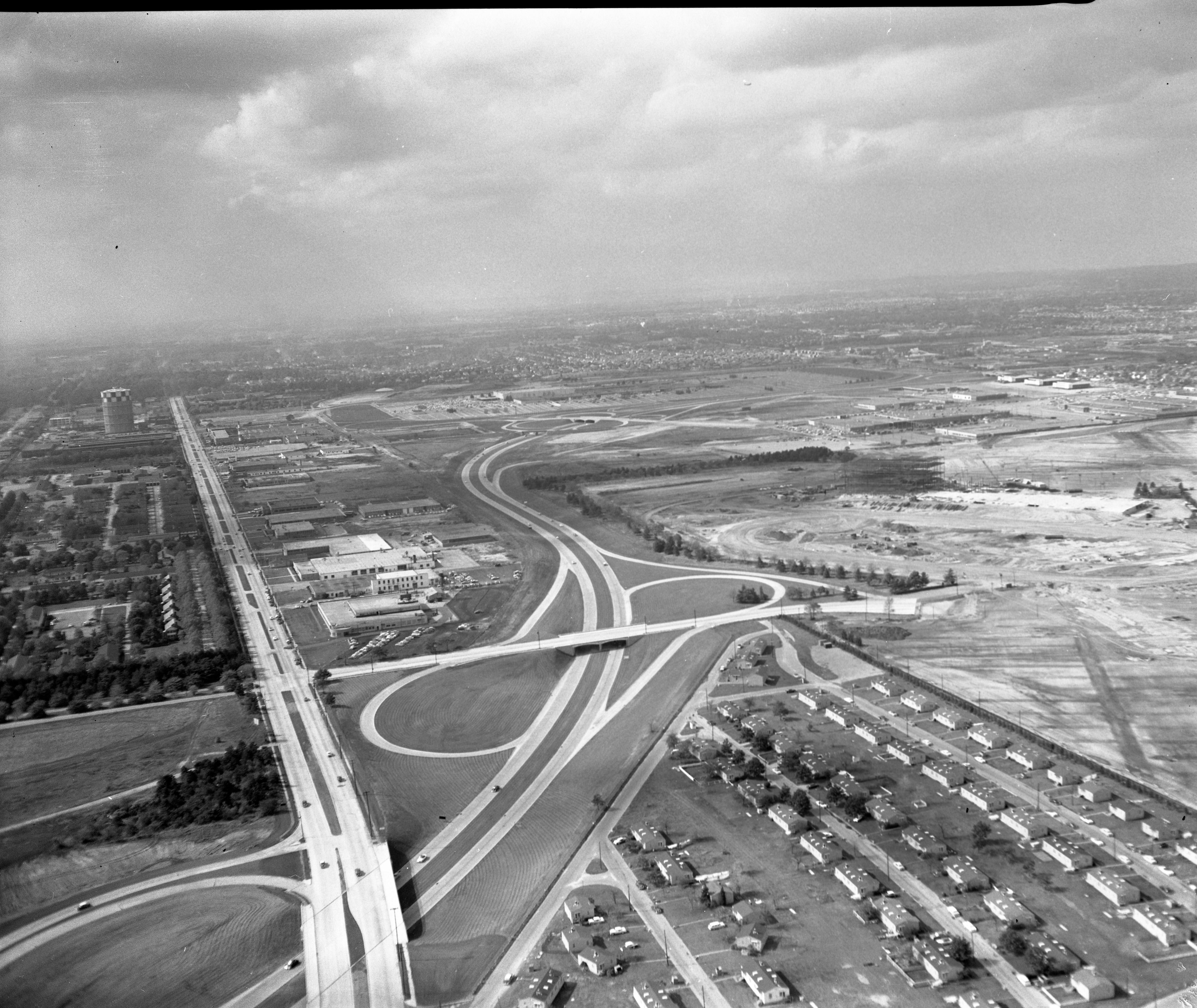
Looking northwest over the newly opened Meadowbrook Parkway Extension towards Roosevelt Field Shopping Center in East Garden City. Stewart Avenue is on the left.
- Approximate month and year. Provide a rationale.
October 1956. Rationale: The state of the Roosevelt Field shopping complex and automobiles on the the Meadowbrook Parkway Extension which opened on October 13, 1956.
- The location of the LIMP
Remnants of the LIMP ROW can be seen to the right of the housing complex at the right corner and runs parallel to Stewart Avenue on the left.
- Major roads, buildings and housing developments
Meadowbrook Parkway (center)
Stewart Avenue (left)
Roosevelt Field hangars (top right)
Merchants Concourse (Interchange)
LILCO gas tank (Top left)
Mitchel Gardens housing complex (right corner)
Comments (12)
Congrats to Al Prete, David Miller, Joseph Oesterle, Mitch Paluszek, Frank Femenias, Lee Chambers ,Bow Fowler, Ernie, Steve Lucas, George Philippides and John Cunningham for identifying the Mystery Foto location.
Kudos to Mitch Paluszek, Frnk Femenias, Lee Chambers, Ernie, Steve Lucas, George Philippides and John Cunningham for correctly dating the Mystery Foto.
Enjoy,
Greg O. and Howard Kroplick
Close-ups


Comments
Another year of intriguing Mystery Fotos. Happy New Year!
Location: Over the Meadowbrook Parkway in the Uniondale/Westbury area. The photographer is looking NW.
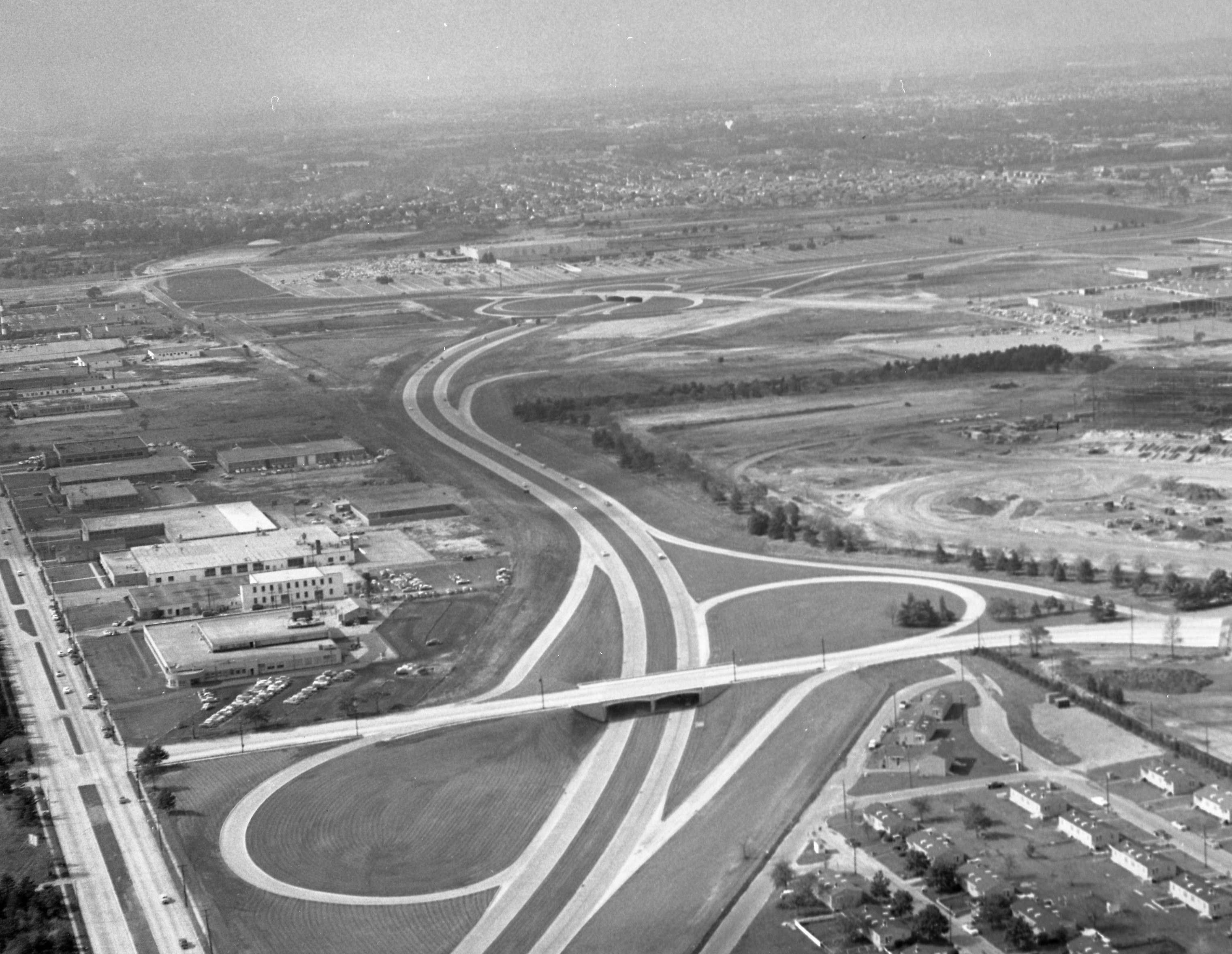
Roads: Meadowbrook Parkway (middle), Stewart Avenue (left). The ramp from E-bound Stewart to S-bound Meadowbrook can be seen. Also the interchange from the Meadowbrook to what today is known as Merchants Concourse (I think it used to be called Avenue “C”), and past that, the ramp to Dibblee Drive and East Gate Blvd. Beyond that, the interchange with the road that goes to present-day Roosevelt Field shopping center.
The LIMP ran right over the section of the Meadowbrook that runs E-W (parallel to Stewart).
Also visible: The LILCO gas tank (center left) and the Mitchel Gardens housing complex (lower right). The Covanta plant has replaced Mitchel Gardens.
I can only place the date as some time in the 1940s, after Mitchel Gardens was built, and before Roosevelt Field airport was closed.
This is the interchange of the Meadowbrook pkwy where it crosses under Stewart ave and directly above that to the right it crosses under Merchants Concourse. The photographer is facing west. Stewart ave runs straight up the left side of the picture and to the left is the military housing near mitchell field. Also, in the distance to the left of Stewart is the old LILCO gas tank. At the near bottom right was additional housing that is now the location of a recycling plant. Way out, top center you can see a rectangular white building that is Macy’s which was part of the newly opened Roosevelt field mall. The right of way for the LIMP is behind the last row of houses starting at the bottom right of the photograph. It runs along the briefly straight (between bends) part of the Meadowbrook parkway, then runs parallel to Stewart ave as you go west before it blends in with the south part of Ring round by Roosevelt field. The Cradle of Aviation was out doing aerial photographs in February of 1957 over Roosevelt field during the release of “The Spirit of St. Louis” movie and conference with Jimmy Stewart as Lindeberg. So maybe this picture was taken along with those shots.
Photographer is up in the air over Stuart Avenue slightly west of the current day entrance to Eisenhower Park, and a couple of hundred yards south of what was the location of the Meadowbrook Lodge of the LIMP. This photo looks so neat and clean.
We see the new Meadowbrook parkway and the area around it looks like it has been groomed like a major league infield. Leading me to believe the Meadowbrook parkway is brand spanking new. We see the LIMP coming from about the 4 O’clock position on the right. Traveling at the edge of what is left of Mitchell Gardens. And ending at today’s Merchants Concourse. Two bridges, one next to the other had crossed the LIMP at this point. On the far side of the picture, the LIMP continues toward the Clinton Rd bridge. But it is too far to away to see anything. Steward Ave and the Meadowbrook Parkway are the main roads we see. Along with Roosevelt Field in the background. We can faintly see an oval where the racetrack will one day be. A stunningly beautifully clear picture.
This shows the interchange at the Meadowbrook and what is now Merchant’s Concourse. The straight road on the left is is Stewart Avenue, and we are looking essentially west. The Motor Parkway is barely visible west of the interchange, but can be seen as a dark line (of trees?) which separates the developed and undeveloped areas in the lower right of the pic. I’d date this as 1956 because it looks like some Roosevelt Field buildings are complete.
Rare photo of what appears remnants of the original Motor Parkway, just south of the newly built Roosevelt Field Shopping Center in East Garden City, Dec 1956. This strip lines up with the original Motor Parkway Right-of-Way. Photo is looking west with the Motor Pkwy Clinton Rd bridge already removed. The Garden City Lodge and Supt’s house are there but difficult to see. Present day Roosevelt Field Ring Road South will eventually occupy the remnant strip, almost. Stewart Av and Meadow Brook State Parkway dominates this photo
Looking Northwest towards Roosevelt Field. To the lower left is Mitchel Field. The tennis courts behind the single family homes on North Road are visible. LILCO ‘Gas Heats Best’ tower is seen on the horizon. Stewart Ave. runs top-bottom on the left.
Meadowbrook Parkway extension runs through middle of photo. Exit ramp for what is today Merchant’s Concourse is not finished. Bottom right is Mitchel Gardens. Former Polo Grounds exercise property and LIMP ROW are beyond those homes. In the distance, the bridge for what will become Zeckendorf Blvd. is present.
Difficult to tell from the distance if construction for Roosevelt Field Mall has begun. Hangers along Old Country Road are still standing.
Parkway extension opened in mid 1956. This couldn’t have been much later than that.
Approximately same orientation seen below. Forgot who contributed the image though.
Stewart Ave. facing west Roosevelt Field Mall North-West off the Meadowbrook in the Early 1950’s
Location and orientation of the photographer
Looking a bit south of west from about over the Stewart Ave/Merrick Road
interception
Approximate month and year. Provide a rationale.
Stumped here. The Roosevelt Field Mall is evident, opened 1956. The Roosevelt
Field Harness track looks to be under (re)development which occurred in 1956.
The location of the LIMP
Along the top of the image you can see the turn north past the mall. Most of the
ROW was absorbed by the parkway here.
Major roads, buildings and housing developments
Stewart Ave. Meadowbrook Pkw with overpasses to Merchant’s Concourse,
Zeckendorf Blvd, and LIRR to industrial area. Roosevelt Field Mall
We are looking roughly east-northeast over the Meadowbrook Parkway and Stewart Avenue in E. Garden City / Westbury / Uniondale. Based on the newness of the parkway and Roosevelt Raceway construction the date is probably late 1956 around October of that year. The LIMP runs at a diagonal (east-west) to the right of Mitchel Gardens housing development. Other roads are: Ellison Avenue-Avenue “C”- Endo Blvd.; Zeckendorf Blvd.; and Linwood Av. / Kenwood St. / Willow St. in Mitchel Gardens. Other buildings are: the just completed Roosevelt Field Shopping Center; three old hangars from Roosevelt/Hazelhurst Airfield and the LILCO gas tank.
The photographer is over East Garden City facing west.
Approximate year would be between 1956 and 1962 as the Meadowbrook parkway is built and operational- and Macy’s can be seen in Roosevelt field but Gimbels, built on the north end of Roosevelt field in 1962, cannot be seen. I don’t see the Roosevelt Raceway grand stands, which went up in 1957, so I guess 1956 is my final guess.
Remnants of LIMP can be seen just south of Roosevelt field, by Ring road then running parallel to Meadowbrook PKWY and Stewart Avenue
Major roads include Stewart Avenue, in lower left, Merchants concourse in the bottom crossing over MBPkway on to Stewart Ave, Meadowbrook PKWY and Zeckendorf in the distance with bridge over parkway
Major buldings/structures include Stewart School in upper left ( I can see the trees, the school itself is less clear, but since I attended Stewart School , I know that it was there then), the Lilco Gas Tank on Stewart Avenue, the A and P warehouses next to the tank and General Bronze, across the street from the Gas Tank. Hoping someone can identify the buildings in the near field on Stewart Avenue- I know that the Garden City Bowl was around there in the late 60s, not sure about the late 50s. Also, you can still see some airplane hangars along Old Country road top right I believe. Great photo. Thanks
Looking forward toward’s this week’s answers. I think I got it this time!
looking west, northwest over hempstead plains - garden city, mineola, carle place
roosevelt field mall is there and the meadowbrook parkway is finished - 1956-59
motor parkway is gone - curls around the back of the mall and continues through the middle of photo
mitchel gardens, lilco tank, clinton road, old cc railroad with tressel visible in the the middle of the on ramp to the mbrook. zeckendorf blvd, stewart ave
Amazing details by Lee Chambers and George Philippides. Love this historic website!
Howard, Was the Meadowbrook Parkway portion super imposed on the photo ? Look at Stewart Ave., the western portion is darker or is that just sun light into shade ?
Al,
I think that’s just cloud cover.
I love this website.
In George’s comment above with the closeup pictures, the top pic is now 711 Stewart Ave. I had tried in the past to research the history of the building and found one NY Times article that said, “In World War II, the structure was a Grumman factory for building Navy fighter planes.” I haven’t been able to find anything else.