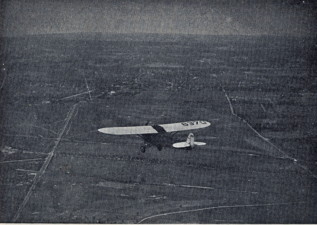
Mystery Friday Foto #21 Solved: The Fairchild FC-2 NC6370 flying over the Motor Parkway in East Meadow courtesy of the Fairchild Airplane Manufacturing Corporation (circa 1928-1932)
Greg O. challenged you to solve this weekend's Mystery Foto.
Answers to the Mystery Foto questions:
Identify:
- The location and orientation of the photographer
Flying north over the Hempstead /Salisbury Palins in East Meadow.
- The major roads in the Mystery Foto
Merrick Avenue (left), Bellmore Road (Newbridge Avenue) (right)
Long Island Motor Parkway and Stewart Avenue across the diagonal and above the Central Railroad
- Structures related to the Motor Parkway
Meadow Brook Lodge, Merrick Avenue Motor Parkway Bridge and the Meadowbrook Bridge.
- The approximate year of the Mystery Foto. Provide a rationale.
Circa 1928 to 1932. Fairchild Airplane Manufacturing Corporation was founded in 1928.
Kudos question: Identify the airplane. Provide a rationale.
Correction: Fairchild FC-2 built on June 6, 1928 in Farmingdale, New York. Exported to Canada on June 7, 1932.
Comments (7)
Congrats to Michael Labarbera, David Miller, Art Kleiner, Steve Lucas and Frank Femenias for correctly identifying the location of the Mystery Foto.
Kudos to Art Kleiner for his super documentation of the Fairchild FC-2 NC6370.
Enjoy,
Howard Kroplick
Close-Ups
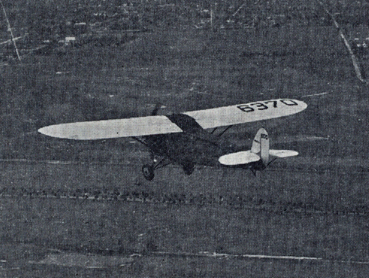
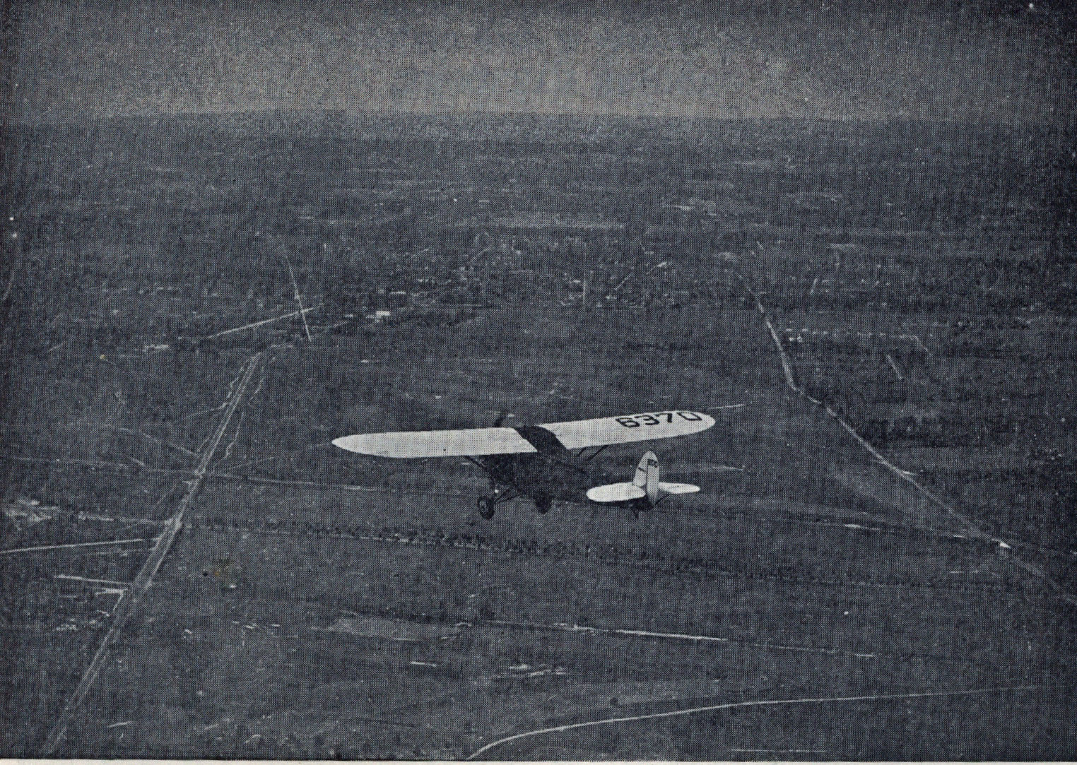
Kleiner' Korner: NC6370
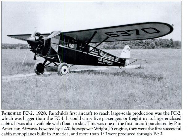
Here's another photo of the FC-6370 in use by the Wadhams Oil Company. From the book "Long Island Aviation Manufacturers" by Joshua Stoff.
Art


Comments
Looks like the plane is flying NW toward Old Westbury over Merrick Avenue. You can see East West Motor Parkway at the top middle, Stewart Avenue east west with the trees and the LIRR Central branch with its little soutwest road toward the Meadowbrook Club. Guessing the year 1922 or earlier as there is nothing else to see in the picture. Looks like at the top of the Picture is Old Country Road at Post Avenue
This is over the Salisbury plains with the photographer facing north. The 3 horizontal parallel lines from top to bottom are: LIMP, Stewart ave., and the LIRR central branch. The vertical road on the left is Merrick ave. and Meadowbrook hunt club rd. is the diagonal road on the left that ends at Merrick ave. The Salisbury plains station is located just below that. The white speck on the right side of the photograph is LIMP meadowbrook overpass, (over Newbridge rd. / East Meadow ave). On the lower left should be the Salisbury links clubhouse but I can’t make it out. If its not there then the photo was taken before 1932.
Looking north over Salisbury (Eisenhower Park).
Merrick Avenue running vertically on the left. Motor Parkway directly beneath the plane. Stewart Avenue beneath the Motor Parkway. Bellmore Road (Salisbury Park Drive) going vertically, slanted, on the right.
Merrick Avenue and Meadowbrook (Bellmore Road) Parkway Bridges, Meadowbrook Lodge and entrance.
1928 - 1930 (see answer to the kudos question.
Plane: A Fairchild FC-2 which was built in 1928 in Farmington, NY and exported to Canada in June, 1932. The plane was in San Francisco’s Crissy Field in 1931 so I’m assuming it was on the east coast prior to that. Used by Fairchild to provide aerial photography.
Log of the NC6370 in Crissy Field in 1931. The FC-2 at that time was owned by Owned by S.T. Yasolis whose home base was Mills Field in San Franscisco. Info. from the oaklandairfield.org. Amazing what you can find on the internet!
Image is not really clear enough to say definitively, but I’ll guess looking north over East Meadow with Merrick Avenue on the left and Newbridge Avenue (Bellmore Road) on the right. Stewart Avenue and the LIMP run horizontally under the plane. Structures would then include the Merrick and Newbridge bridges along with the Meadowbrook Lodge. I’ll guess the date around 1937 since the bridges appear to be intact. As for the plane: ????.
Flying over Salisbury/Eisenhower Park looking NNW.
Four horizontal roads at center are CRR, tree-lined Stewart Ave, Motor Parkway, and Old Country Rd. Also part of the Meadow Brook Club access road can be seen diagonal off Merrick Av.
Two vertical roads from left to right are Merrick Ave and Old Newbridge Av/Bellmore Rd (now Salisbury Park Drive).
Hard to see but related Motor Pkwy structures are Meadow Brook lodge, Merrick Av bridge, and Bellmore Rd bridge.
Guessing around 1930s, plane unknown
The Fairchild Plant and Flying Field was located at FARMINGDALE, L.I., N.Y., not Farmington. Originally on Motor Ave. (later Liberty Aircraft), later in East Farmingdale on Conklin St. (later became Republic Aviation / Republic Airport).
Howard Kroplick: Gary, good catch, thanks!
WOW! This particular Fairchild aerial photo contrasts to their usual high resolution aerial photography that was well known at the time, and still today. I can’t explain how this low resolution Fairchild photo was even processed for viewing!