Mystery Foto #21 Solved: A 1914 Map of the Garden City Section of the Long Island Motor Parkway
Bill Bellmer challenged you to solve this weekend's Mystery Foto.
Bill and I will be presenting more details on this Mystery Foto this Thursday at the spring meeting of the Long Island Motor Parkway Preservation Society at 7:00 pm at the Bethpage Public Library.
Mystery Foto questions:
- Identify the location
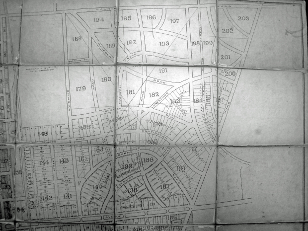
The Mott section of Garden City
- What is the date of the map? Provide a rationale.
1914. A previous VanderbiltCupRaces.com post.
- Kudos question: Why is this map significant?
Documents the need for the"Mayan Ruins" bridge. The planned Lawrence Road was never built by the Garden City Corporation.
Comments (15)
Congrats to Brian McHale, Joe Oesterle, Ron Ridolph, Jimmy, Al Prete, Casey DeNicola, Tim Ivers, Roy Warner, Sam Berliner III, Dick Gorman, Art Kleiner, Steve Lucas, George Philippides and Frank Femenias for identifying the Garden City map.
Kudos to Steve Lucas and George Philippides for linking the map to the Mayan Ruins Motor Parkway Bridge.
Enjoy,
Howard Kroplick
Close-Ups
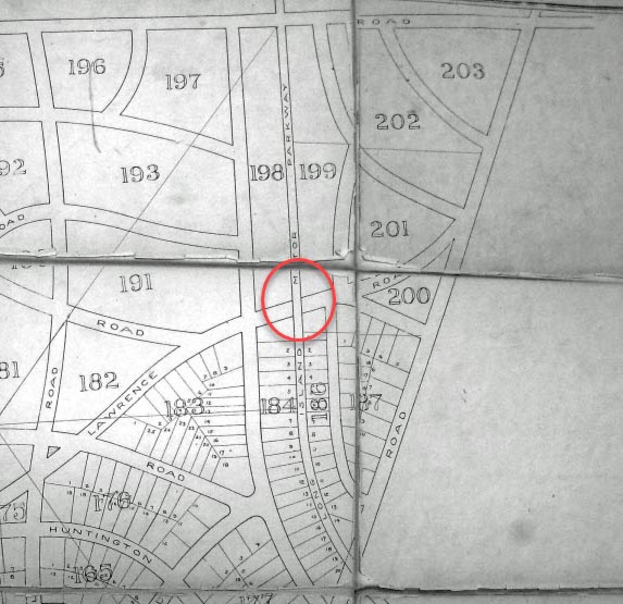
Location of the Mayan Ruins Bridge
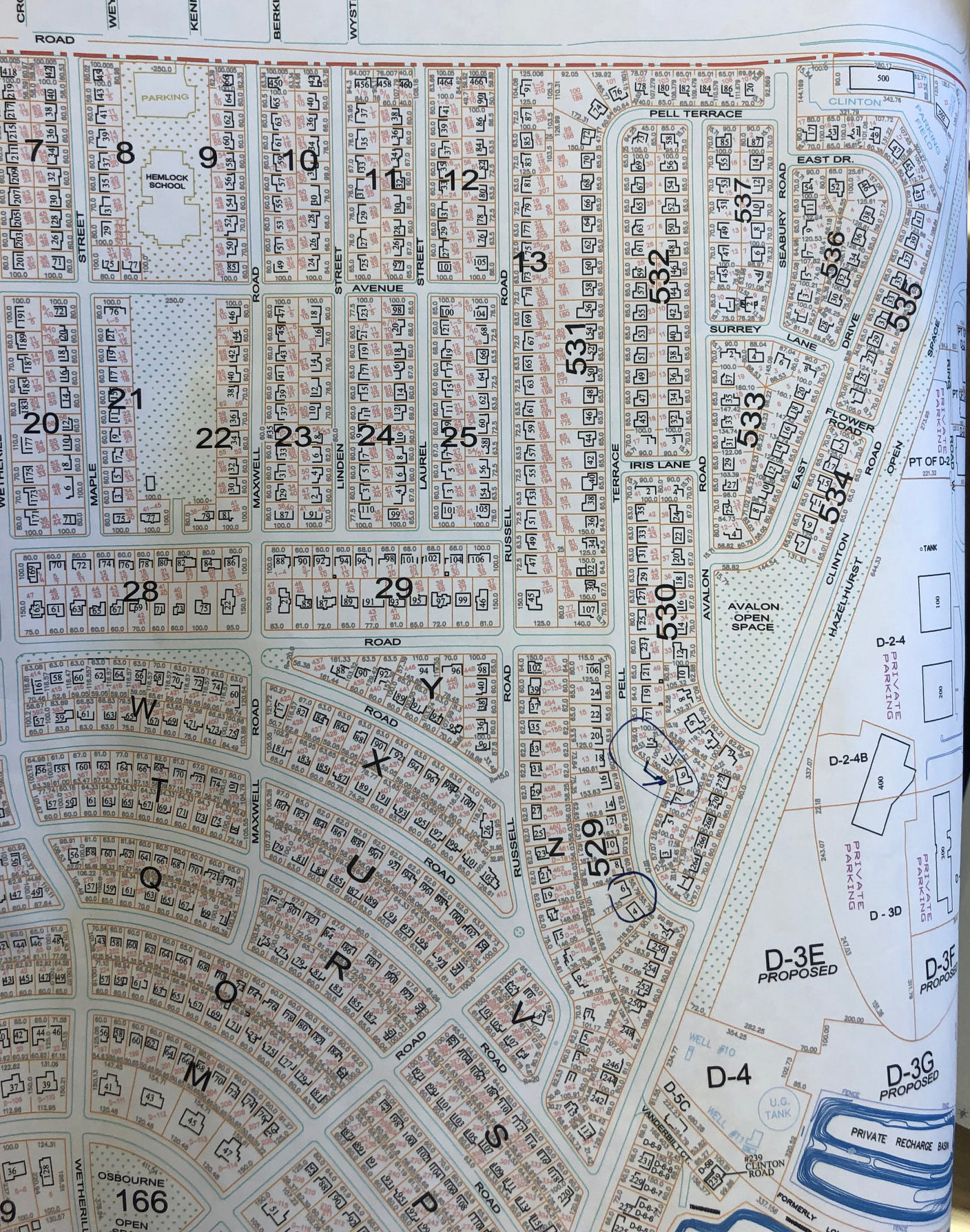
Current mapping of this section of Garden City
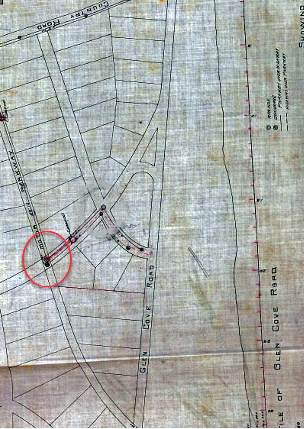
A Motor Parkway survey of the area.


Comments
Top road is Old Country rd. Parkway runs along Russel rd in GC turns east before Stewart ave.
The map appears to be a plan for Garden City. South of Old Country Rd, and north of Stewart Ave. The layout was not used as proposed. The map is probably made in the 1920’s or 30’s, because the military hospital is no longer there.
This photo is of a planned and filed subdivision showing ( S/B/L ) Section. Block
and Lot Number in Garden City, NY. Dated after the closing of the LIMP, probably
after the end of WWII in the mid- 40’s and or early 50"s. Map could also serve for
zoning, assessments, special districts, taxing needs, fire, postal and school
district etc.
1) We are in Garden City
2) Between 1927 and 1939. The area around Triangle Park, Plot #166 wasn’t developed in 1927.
3)The Mineola Fairgrounds is misidentified? Why was Prescott Rd. changed to Wyatt Rd.?
Location: The Mott section of Garden City.
Date: I would have to say any time from the 1920s (when the Mott section was built, by heirs to the Mott apple juice company fortune) and 1938 when the LIMP closed (the LIMP looks like an active road on the map).
Significance: The old Mineola fairgrounds in the northwest corner of the map? This land was taken by Nassau County in 1953 and is now the site of the county government buildings.
This is around the Garden City/Hempstead/Westbury borders.The road with the large open space on the right is Clinton Ave.The large open space is Roosevelt field.The LIMP crosses Clinton and heads east.The divided road at the bottom is Stewart Ave.Old Country road is at the top,running left to right.Don’t know what the date might be,I’d have to say no later than 1930s or 40s,just a guess.Significance? Shows whose backyard LIMP ran thru! haha
East Garden City
Old Country Road at top; Stewart Avenue across bottom; Clinton Road on right.
The map shows the proposed streets in 1914. The LIMP is crossing Clinton at right.
Old Garden City, with the Motor Pkwy passing south along the border of today’s Roosevelt Field, and then east at the southend of today’s Roosevelt Field. The Queens/Nassau Parade Grounds became the site of the WPA’s Supreme/Nassau (with the beautiful topographic LI map in the lobby), and today’s Supreme/Nassau.
It’s the Garden City section of the LIMP, corresponding to the aerial photo at the beginning of this Newsletter, with North at the top, Clinton Road up the middle right, Old Country Road across the top, and Stewart Avenue across the bottom, and drawn as the Mott section was just starting to be developed in the ‘20s. Roosevelt Field is the blank area at right. Sam, III
Mystery Foto #21…This map shows northeast Garden City. And the date is 1914 based on info I found in our very own VCR website.
As for the significance, the map illustrates the proposed street layout for northeastern Garden City.
Garden City
Circa 1914: similar map found and dated on historicmapworks; no camp
Mills which began in 1917. Street names don’t correspond to today’s names.
Looks like there was no bridge over Clinton Road where the map shows there would be.
We’re looking at a section of East Garden City bounded by Old Country Road, Clinton Road, Stewart Avenue, and the LIRR Garden City-Hempstead Line with north at the top. I’m guessing the date to be around 1919 since the layout of the streets and many of the street names are different from what they eventually became. The significance may be that the “Mayan Ruins” (or Transverse Road) bridge was apparently designed to originally go under the LIMP as Lawrence Road.
This is a view of the northeast corner of Garden City by Roosevelt Field.
Old Country Road is the major road on top running left to right, and Clinton( Glen Cove Rd then) is on the right side running up down. The date is some time around 1909 because this map represents the original proposed subdivisions of the Garden City company property. The final subdivisions/roads were quite different. I know because I grew up on Avalon road, not shown on this map, which is somewhere in sector 202.
The map is significant because it included plans for a road to cross the Motor parkway around where “Lawrence” street( which was never built) crossed the parkway. In anticipation of that crossing the abutments were built, somewhere just north of what is now Transverse Road. However the original intersecting road and full bridge were never built—and those abutments are now known as the Mayan ruins.
Village of Garden City including the Mott Section at center bottom (heirs of Mott Apple Juice), Mineola Fairgrounds top left corner, Roosevelt Field top right. This map (early ‘20s) likely a first draft, anticipating housing growth after Camp Mills (1918-1919). More streets south of Old Country Rd would be added. The map numerals do not correspond with today’s Section/Block/Lot system. This prime section of real estate also had easy access to the Motor Parkway. The Garden City lodge would eventually be moved in 1989 to the extreme bottom left corner of the map.
Didn’t get a chance at the mystery photo but this looks like the planned Garden City Mott section just West of Clinton Rd that was never built.