Aerial Views of the Motor Parkway in Bethpage
Tony D: I would like to thank you for writing your books on the LIMP and the Vanderbilt Cup Races. I saw that you have an aerial photo of Stewart ave and the LIMP in Bethpage from the 50's. It stops at the south side of Central Avenue,do you have a photo of just north of this? I would like to see how far it was from the "town " of Bethpage. Thanks again .
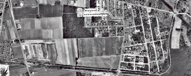
Tony, thanks for the question! Here are aerial views of the Long Island Motor Parkway in the Bethpage area taken in 1926 and 1950:


Corrected December 12, 2010: Long and closeup views of the Motor Parkway in Bethpage (marked by the dotted line) as seen in 1926. The straight diagonal line is the Long Island Rail Road. The rail track and Central Avenue intersected at the Motor Parkway Bridge.


These 1950s aerials showed the location of the two Motor Parkway "Deadman Curves" in Bethpage.


Links to related posts on VanderbiltCupRaces.com:


Comments
Regarding the Motor Parkway in Bethpage:
Is it not true that the straight diagonal line is the LIRR Main Line (not the Central Railroad) and the photo showing the track and bridge is facing northwest, also showing the Main Line? I think the Central Railroad is the horizontal line at the bottom of the map.
Hi Bill:
You are 100% correct. I have one too many Centrals at that intersection!! The Central Line was located south of the Motor Parkway.
Howard
Hi Howard
I always thought there was only ONE dead mans curve that was located south of what is pictured here. My recollection was that deadmans curve was running just north of the Central RR which fragments of it still exists today. I would never have been able to route the exact LIMP ROW (although I’ve tried) going north towards bethpage park (central park) without these aerials. This is awesome!! Keep it up!
And Bill’s picture of the railroad I believe is facing NE not NW