Kleiner’s Korner Vote Request: The Ongoing Debate Over the Highest Hill on Long Island

Two Long Island hills have battled to be the highest elevation since the late 1800s. Harbor Hill in Roslyn and Jayne's Hill in West Hills have been documented as the two highest elevations on Long Island but which wins the debate as the highest?
As shown below, two landforms play prominently in the topography of Long Island: the Harbor Hill Moraine and the Ronkonkoma Moraine. Since the late 1800s a debate has raged over which hill contained in each landform is the highest. Here are documents and photos that you can use to cast your vote.
By the way, last year I wrote this post at 63' above sea level!
Art Kleiner
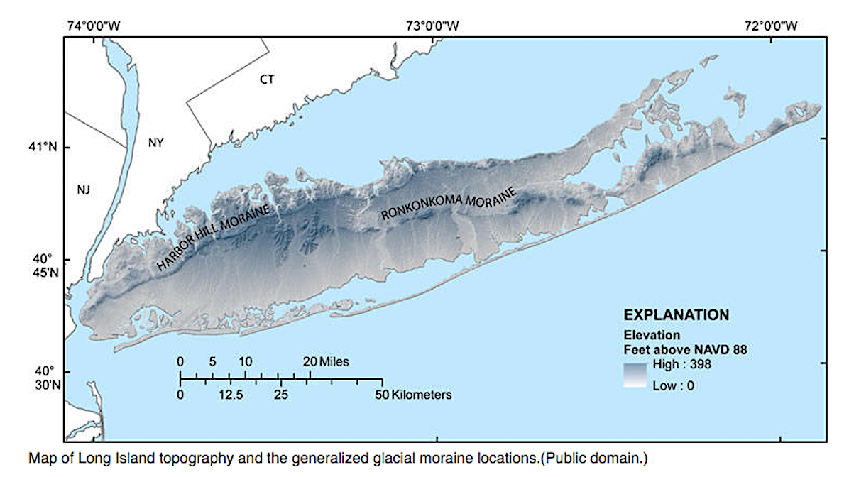
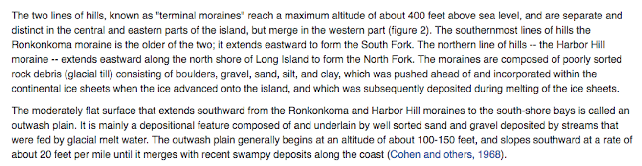
Some Geographical Background
Courtesy of the United States Geographical Service
Wikipedia
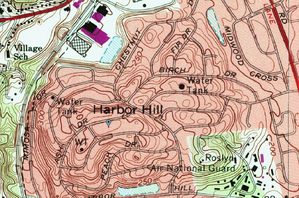
Harbor Hill, East Hills
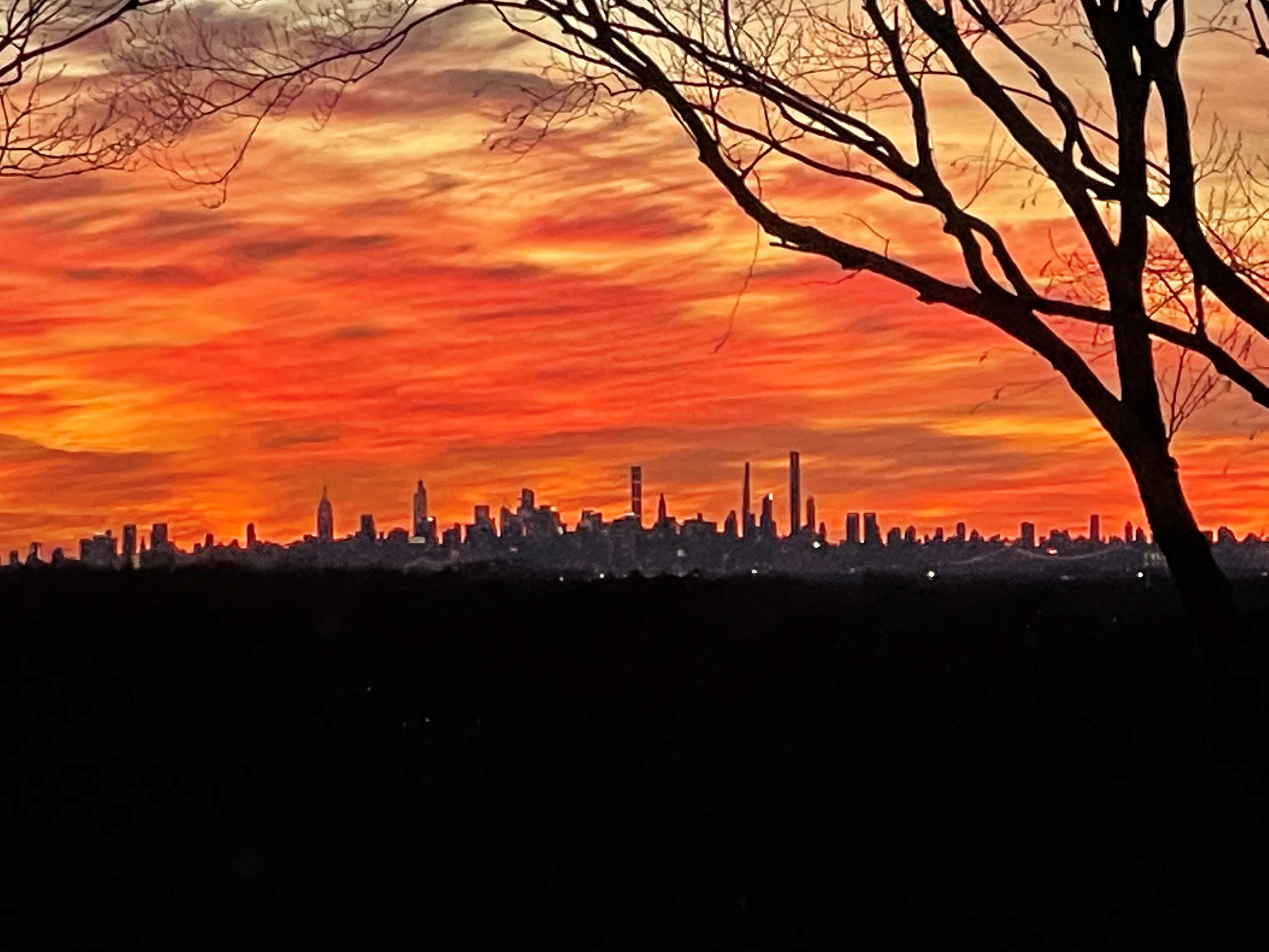
A recent spectacular view of the Manhattan skyline from Harbor Hill.
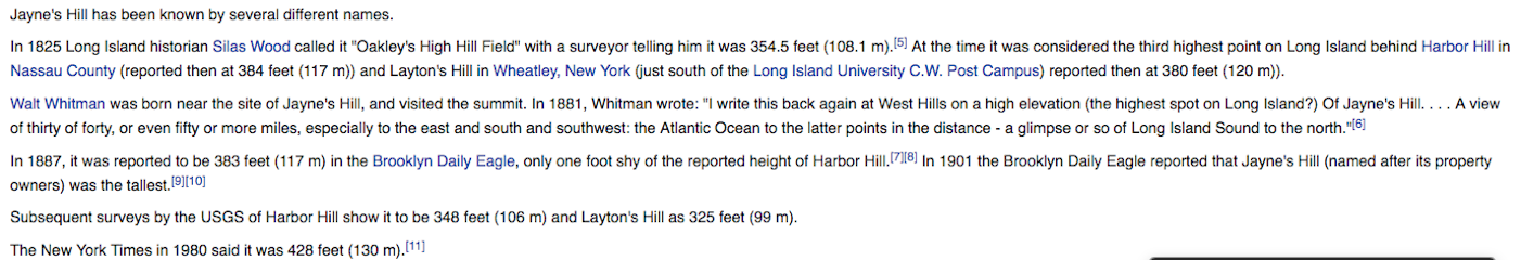
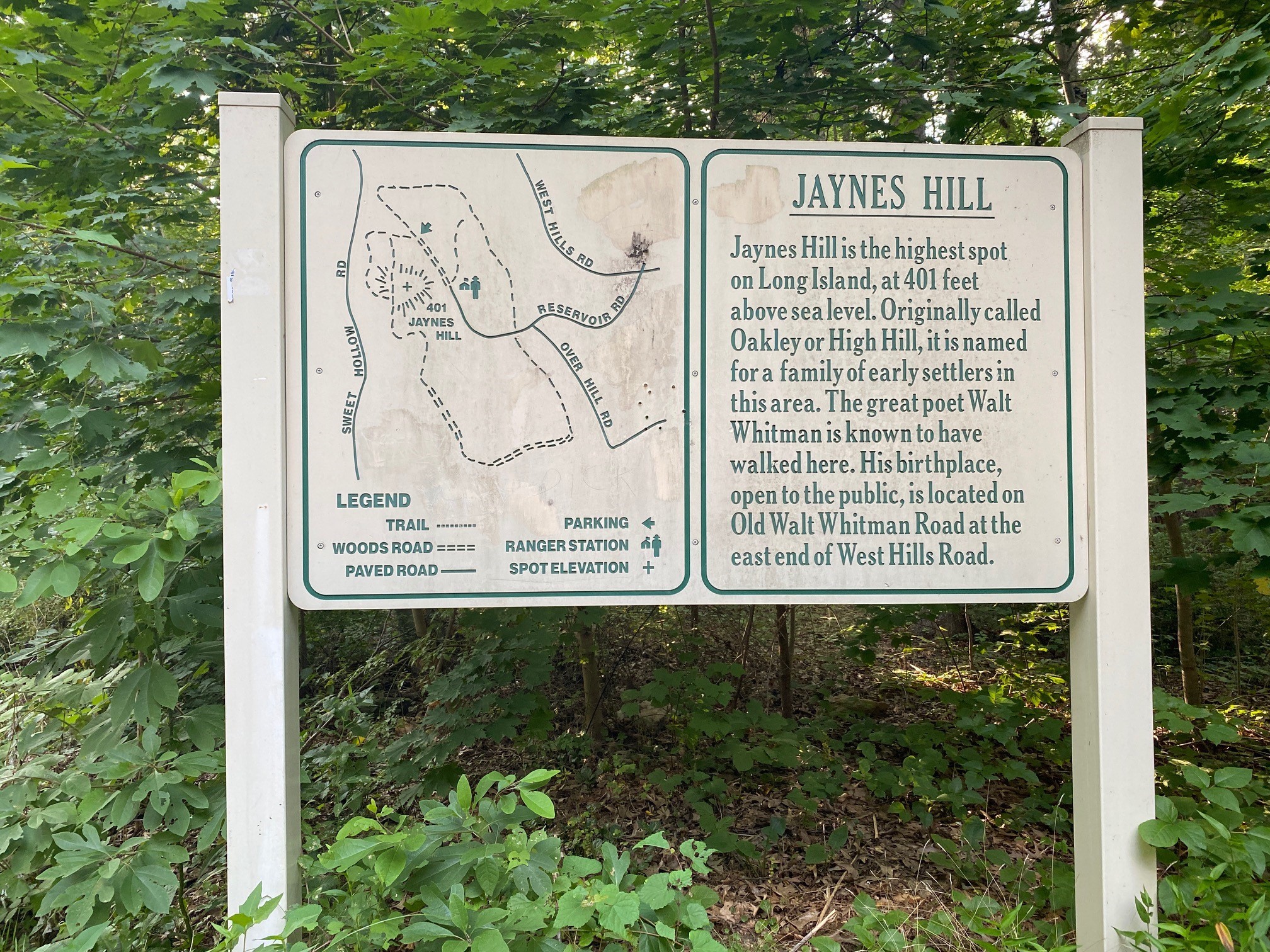
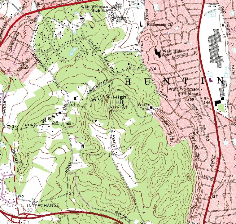
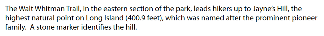
Jaynes Hill, West Hills
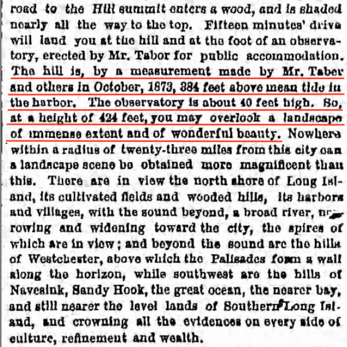
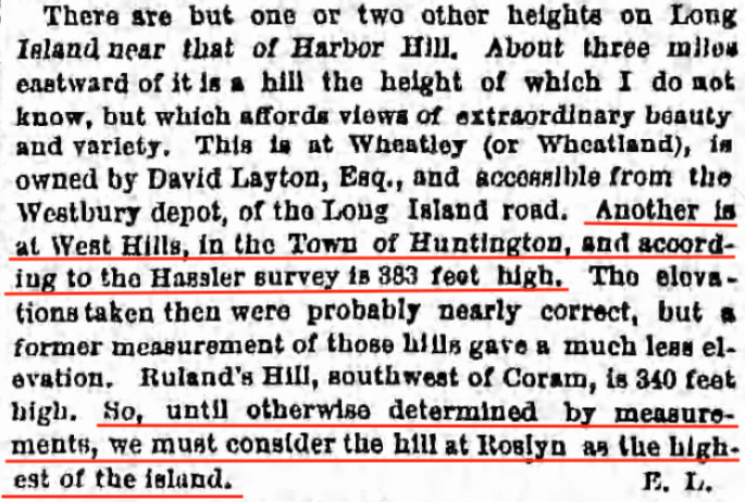
The Debate Begins in 1875
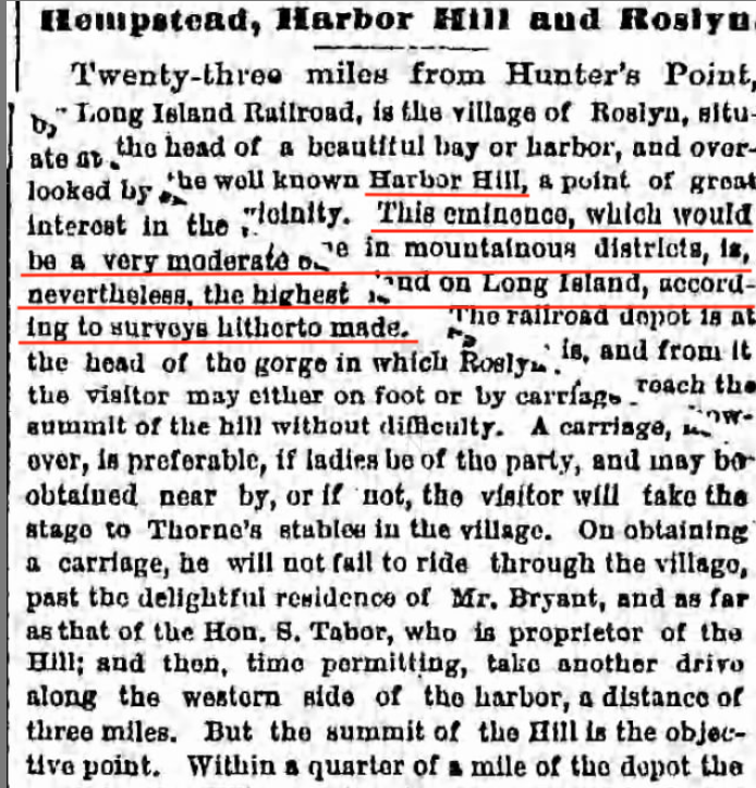
The Brooklyn Daily Eagle ran this article in 1875 describing the highest elevations on Long Island. (Brooklyn Daily Eagle Aug. 2, 1975)
And followed up two years later with another article noting Harbor Hill being the highest elevation on Long Island. (Brooklyn Daily Eagle, May 15, 1987)
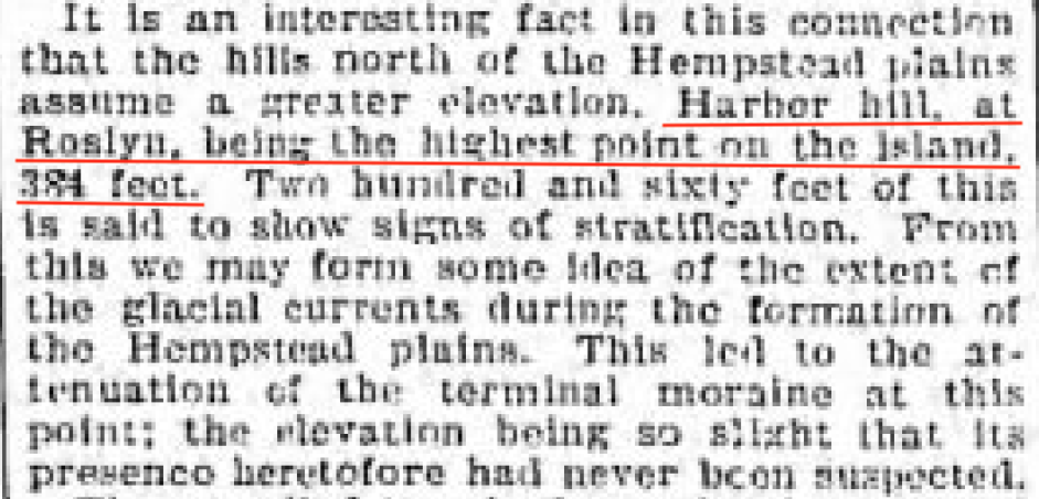
And Continued into the 1900s
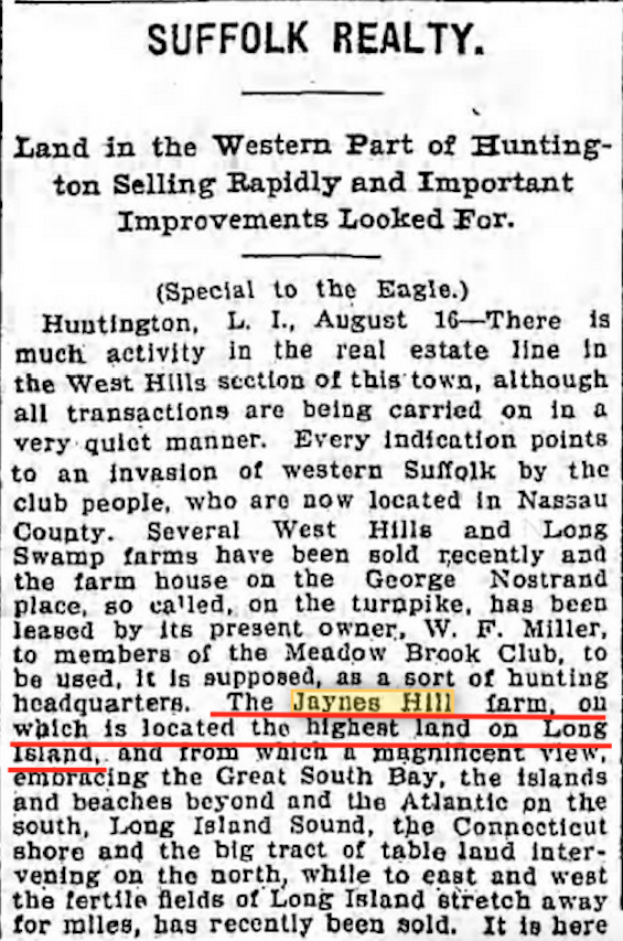
Brooklyn Daily Eagle Aug. 16, 1902
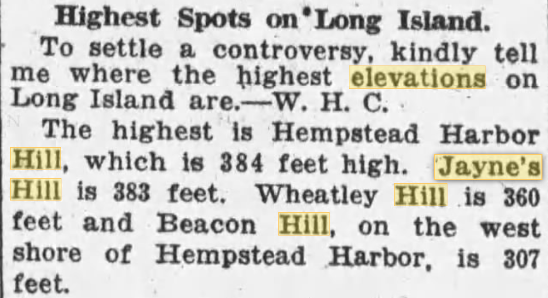
Brooklyn Daily Eagle Mar. 21, 1920
Other Points of View
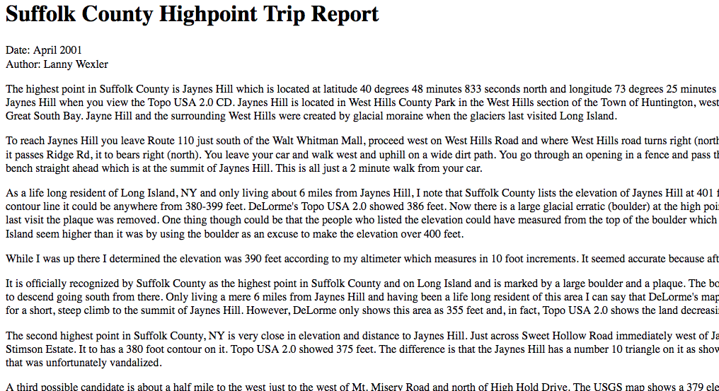
Suffolk County, Lanny Walker
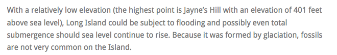
Williams.edu

The Most Accurate Measurements Taken?
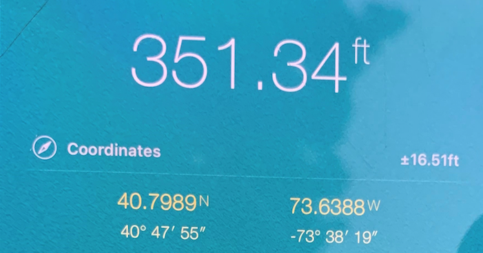
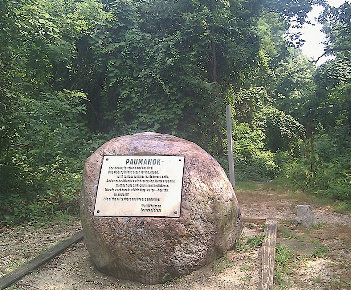
Actual measurements taken in August, 2021 using an app. on Howard's cell phone might solve the debate once and for all. What do you think?
Harbor Hill
Jaynes Hill


Comments
The South Huntington Water District has been sure that Jayne’s Hill is the highest point on L.I. since 1926.
Art, Recall that the hill Deepdale in Lake Success was built was in the hunt also. Story goes top of the hill was reachable only by foot and one could see the Atlantic Ocean and Connecticut. Vanderbilt lowered the hill substantially in order to get a larger level area for his residence and auxiliary buildings “hundreds of cart loads of soil were removed and were used to fill in the swampy/marshy areas of the Lake.”
First of all happy new year everyone!!
Through my Gold Coast research I learned that Otto Kahn tried to purchase West Hills land because it was the highest point in Long Island. The owner wouldn’t sell, so Kahn wanted to make a point with all of his money, spent the next two years building up the land where Oheka Castle was built and THAT property is supposedly the highest point in Long Island.
Also, Walt Whitman would supposedly go up to the top of the West Hills land and write his poems. He lived nearby, as you all know. He liked to be at the high point.
Dave- further to your point is that the Cold Spring Harbor train station was built specifically for the construction of Oheka and bringing in all the soil for it, later becoming a regular LIRR train station.
Although I don’t think most people include it because it was man-made and not natural topography.
Oheka and Jaynes Hill are both on the moraine, so the land where Oheka was built was already well above sea level. But Otto Kahn wanted to stand out I guess : )
I know there were actual Ski Jumps around Long Island in the past. Near me in Farmingville there was Bald Hill Ski Bowl ( now the location of Brookhaven Amphitheater ). Read that the bowl lasted until the 1980’s. The entrance rd is still named Ski Run Lane. 330+ ‘ ASL
Im getting Harbor Hill as the highest point in Nassau at 348.0 ft., andJaynes Hill the highest in Suffolk at 400.9 ft. Oheka castle and West Hills are nearby the summit at Jayne’s Hill. Greg, I’ve heard of moving mountains but never elevating them. Prohibitedly expensive likely.
The Brooklyn Eagle 1875 article mentions “Ruland’s Hill, southwest of Coram.” Was this another name for Bald Hill, which IS SW of Coram? From the veterans memorial on Bald Hill (next to the aforementioned amphitheater), on a clear day in winter, you can see both the Long Island Sound and the Great South Bay.
As a lifelong Long Islander I was always told that the highest point is Jayne’s Hill.
Al - Below I found a reference to Rulands Hill, Smithtown. From U.S. Coastal Geodetic Survey.
It’s me again Al, lol - Your thoughts of Ruland Hill being in the vicinity is correct. There was a Mr. Ruland that owned properties around Bald Hills during the 1800’s. Couldn’t find any Ruland reference mapwise in Smithtown. Up until 1960, there was a Fire Tower Lookout on this hill, also referred as Telescope Hill. One could see for miles from atop. This location is now the Radio/Tower Station for 97.5 WALK FM. Below I marked a 1947 & 1970 Topo Map Overlay as best as possible, and a today view. When driving on Blue Point Rd at this point, it’s like a roller coaster. South Shore is visible.
Although this variation of opinions - perhaps even still somewhat of a controversy in this day and age - may not mean much in The Great Scheme of Things, it is a beautifully researched, documented, and written treatise on an interesting subject which probably has a large appeal to a limited audience both on and around Long Island. To all those who contributed to this piece, thank you so much.
Putting an FM radio tower like WALK on the top of a hill at high elevation is a no brainer - FM signals are line of sight and do not follow the curvature of the ground as AM signals do.
If any large object (such as a mountain, tall building or even airplane in flight) were to block the signal, reception would be difficult at best, next to impossible at worst (it isn’t accidental that before the WTC, virtually every FM antenna (and later, TV antenna) were on top of the Empire State Building for that very reason.
Hence, tower height above average terrain is critical for FM antennae, even more so than the actual transmitter output power.
I find it interesting that even in the twenty first century, the elevations of these “mountains” are not definitively known. I think there is no debate that Jayne’s Hill is the highest on Long Island. As for OHEKA, a comparison of the 1903 USGS topographical map and the 2019 map shows that the hill the mansion sits on remains at 280’—not nearly high enough to claim highest honors and debunking the claim that Kahn elevated the hill.
A wonderful posting Art!
This “debate” is actually a trick question well-known to old geology majors like myself.
A hill that raises 250 feet from sea level, is a higher (taller) hill than a hill that raises 200 feet from a base elevation of 100, even though that second point has the higher elevation (300 feet).
“Highest point” usually equates to highest elevation, so Jayne’s Hill (also known as High Hill) is the highest point on L.I., usually measured as 399 feet (between 380 and 400 according to the latest USGS mapping).
However, the hill rises from the Huntington Valley, the floor of which Route 110 more-or-less traces by the Walt Whitman Shops. This floor has an elevation of about 150 feet. (An old benchmark by the Walt Whitman Home is at 153 feet.) Therefore, one can say that Jayne’s Hill rises about 399 minus 150 or about 250 feet from its base.
Harbor Hill, according to the latest USGS mapping is at an elevation between 360 and 380 feet. However, if we were to walk the flank of the hill, we would be walking all the way down to Roslyn Pond, elevation 13 feet. 360 feet (and Harbor Hill is higher than that) minus 13 feet is 347 feet, making Harbor Hill the “highest/tallest hill,” as measured from its base.
Some of the other postings use old USGC measurements or maps that can vary from modern, more accurate measurements. Howard, your cell phone readings illustrate the reason geophysicists don’t use cell phone to take elevation measurements!
As for Al V.‘s side issue:
A comparison of 1898 and 2019 USGS topographic maps makes it unlikely that Deepdale was ever the highest point. In 1898, the location of the future mansion was between 240 and 260 feet; in 2019, the same location was measured as between 250 and 260 feet. (By the way, in the same 1898 map, Harbor Hill was measured at 391 feet and in a related 1900 map, High Hill was measured in excess of 420 feet, illustrating how old maps got things wrong.)
Thank you David and to all for adding additional insights and comments into this debate. Very much appreciated!